Renfrewshire a Scottish County’s Hidden Past

The book launch by Derek Alexander of ‘RENFREWSHIRE a Scottish County’s Hidden Past’ was held in Waterstone’s in Braehead on the 14th of June. Derek Alexander and the late Gordon McCrae, are co-authors of the book. In his address at the book launch Derek read some excerpts from the book and expressed his hope the book would encourage others to look for Renfrewshire’s ‘hidden past’.

renfrewshireDerek is the Head of Archaeological Services for the National Trust for Scotland and has been an active member of Renfrewshire Local History Forum for many years.

Gordon was a noted local historian and studied archaeology at Liverpool University. Past students of Paisley University (the University of the West of Scotland) will remember him as its Depute Librarian.

Gordon was a founder member of Renfrewshire Local History Forum in 1988. His passion for local history and archaeology and unbounded enthusiasm is almost legendary. He organised and led numerous Forum field trips round the county, liberally sharing his extensive knowledge – and boiled sweets! His sudden death in 2005 was a tragic loss to the Forum. This book has been dedicated to his memory.

The book covers archaeological sites in Renfrewshire, East Renfrewshire and Inverclyde from the Palaeolithic to Early Modern Times. The archaeological sites are set within their historical context and the book is illustrated by more than one hundred maps, plans and illustrations.

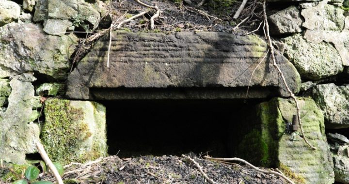
Many local sites, in or near the villages where the Gryffe Advertizer is distributed, are covered in the book. These include, among others, Castle Semple Estate and the Collegiate Church at Lochwinnoch, Whitemoss and Barochan Roman forts near Bishopton, the excavation at South Mound in Houston, the late Bronze Age homestead at Knapps, Duchal Castle near Kilmacolm, the mote hill on Old Ranfurly Golf Course in Bridge of Weir, a moated manor and enclosure near the Wallace Monument in Elderslie, the crannogs in the Clyde at Langbank, Elliston Castle and the Midton Lime Kiln at Howwood, and excavations at the Old Churchyard and the Weaver’s Cottage in Kilbarchan.

For those interested in the seeking out archaeological evidence for the history of Renfrewshire, ‘RENFREWSHIRE A Scottish County’s Hidden Past’ is an excellent resource. For the many walkers who roam around our local area, the information in the book will provide additional points of interest in their walks. ‘RENFREWSHIRE A Scottish County’s Hidden Past’ (published by Birlinn Ltd.) can be obtained from Renfrewshire Local History Forum as well as from commercial booksellers.

© 2012 Helen Calcluth

Little Kaimhill Cottage

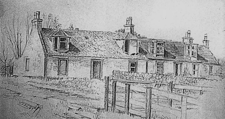
Kaimhill Cottages were built on the site of the former farm steading of West Kaimhill. Both cottages were built in a style common to the agricultural cottages in 19th century Scotland. They were situated in an acre of ground between Kaimhill and Coalbeg Farms to the north of the road from Locher Bridge to Crosslee. The main building consisted of two cottages abutting each other, with various additions built on at later dates.

The original occupant of the first cottage to be built was John Barr, late of the adjacent farm of Coalbog. Perhaps making a career change from farmer to builder, James Barr ‘seized’ (took possession of) in June, 1801, an acre of ground with the houses thereon being part of the lands of Kaimhill called Coalbog. These old farm buildings may have been deemed only suitable material for dismantling and for re-use in the construction of the improved steading buildings then being erected.

John Barr appears to have worked as a mason for some years and later became overseer at Craigends. He continued in the Cunninghames’ employ till March, 1827, when he retired to his cottage at Little Kaimhill. He died in the 1830s and was buried in Kilbarchan East Church graveyard. His wife, Mary, aged 75, still lived in the cottage in 1841.

The next occupants of the cottage in the first half of nineteenth century were coalminers. John Craig was probably employed in the coal pits being worked in conjunction with the nearby lime works by the side of the Gryffe. About 1845 John McGilchrist, a coal and lime master from Balgrogan, Campsie in Stirlingshire moved to Bridge of Weir and lived in the cottage with his wife and six children He became a local coalmaster, probably operating Kaimhill Coal and Limeworks from then until 1859, when it closed and he returned to Campsie.

The 1861 census for Kaimhill had the first notification of two cottages on the site. One cottage was of one room only and was occupied by James Livingston, a retired farmer aged 82, and his wife and son. The other cottage had two rooms and was occupied by William Woodrow, age 36, a grain miller from Kilbarchan, and his wife and family. Later James Stevenson, a carter from Kilbarchan, and his family occupied the larger cottage before moving to Barnbeth where the Stevensons of Barnbeth ran a potato merchants business from a yard in Church Street in Johnstone until 1881.

By 1881 both cottages had been extended. Hugh Wallace, a mason who had owned a building business in Hill Street, Kilmarnock in the 1860s, moved to Kaimhill in 1873. He is a likely candidate for the person who carried out at least some of the substantial changes to the cottages between 1871 and 1881. Sadly, he died in unfortunate circumstances in 1883. He was last seen in Bridge of Weir village on his way home and is supposed to have had a considerable amount of money in his possession. Some days later his body was found in the River Gryffe near a ford. As he was a prosperous man he is an unlikely candidate for suicide. Perhaps he was making his way home via the ford and lost his footing.

Later occupants of the cottage at the end of the century included George McKenzie, a painter and photographic artist, William Lee, a retired farmer, and Hugh Keith, a railway contractor, who died at Kaimhill in 1925. The cottages remained in the possession of the Keith family for another 50 odd years.

© 2012 Bill Speirs,  Johnstone History Society and RLHF

The Barr Loch Mystery

A walker or cyclist travelling on a winter’s day along the cycle track from Lochwinnoch to Kilbirnie may see on the left of the track (just after it passes Hole Farm, about 2km. from Lochwinnoch) a tall chimney, standing in isolation as if stranded among the encroaching trees near the edge of the loch. What was the building? What was it used for?

barrlochThe first known building on the site appears on the 1857 Ordnance Survey map. The accompanying notes described it as a strong stone building supporting a large waterwheel which helped to pump water from the then-drained Barr Loch. It was built at the expense of Colonel McDowall, owner of the Castle Semple Estate from 1841, so it probably dated from the late 1840s.

When McDowall inherited the estate (which included Barr Loch), the loch was used as meadows for oats and hay. Successive owners of the estate from the 17th century had attempted to drain the loch, but with patchy and often short-lived success. The most elaborate scheme (and that inherited by McDowall) was carried out by James Adam between 1813 and 1815. The waterwheel and pump were McDowall’s attempt to make Adam’s system more effective.

By the time of the next Ordnance Survey map in 1897, the large waterwheel was taken down, probably because of problems with the water supply. It was replaced by a steam engine, and the present high chimney was built. The existing buildings were modified and extended to accommodate these changes. The purpose of the building was still the same – to help keep the loch drained – although the pumping mechanism was changed to a more efficient one.

The other change shown on the 1897 map was the addition of a completely new structure at the corner of the pumping-house. This was a sawmill, with its own source of power (a small, water-driven turbine). It can never have been more than a small estate sawmill, possibly supplying the furniture-manufacturing firms of Lochwinnoch.

The sawmill continued in use until after the Second World War, eventually closing in the late 1940s. The fate of the pumping engine is less certain: Barr Loch continued in its drained state until 1946 (albeit as rough grazing), but then flooded suddenly, to become a loch again. Did the pumping engine survive until 1946 or was it abandoned earlier?

© 2012 Ian Brough                (Click on image to enlarge)

The Forgotten Past of a Renfrewshire Farm

High Mathernock, seen here from its reservoir, replaced the earlier farm and settlement which were situated much closer to the Water of Gryfe

The village of Kilmacolm is surrounded by farms with names which go back at least as far as the sixteenth century and possibly to early mediaeval times. High Mathernock, on the north side of the Gryfe Water, is one of those farms whose forgotten history involving milling as well as farming is gradually coming to light.

The modern farm at High Mathernock has stood in its present location since the 1830s and was built in stages by the Shaw Stewart family for the tenant John Lang. Earlier activity at Mathernock, however, took place closer to the Water of Gryfe.

When Timothy Pont surveyed Renfrewshire in the sixteenth century he considered Macharnoch, the waulkmill, and Macharnay (possibly an older name for the nineteenth century Low Mathernock) significant enough to be mapped. All that remains of Pont’s Macharnoch which probably lay just north of Mathernock Bridge is possibly the few courses of stone wall low down on the river bank where, according to folk memory, there was a corn mill. There are two records of a corn mill on the site, one in a record of the Scottish Parliament in 1670, the other in a book about Renfrewshire written in 1782 which states that formerly there was a corn mill there. Further downstream on the other side of Mathernock Bridge lie the probable remains of the waulkmill in the form of a dam to deflect the water course, a partly silted up lade and the remains of walls. The still thriving patch of very old sloe bushes could have used in the dyeing process.

Eighteenth century records show a thriving community at Mathernock involved in a wide variety of occupations. The earliest Kilmacolm Parish Records up to 1745 don’t give occupations. However, in the second half of the eighteenth century we know that people made their living in a wide variety of ways e.g. living and working in Mathernock were a maltman, a smith, millers, farmers, a workman, a weaver, a dyster, a herd, a mariner, a ‘musiciner’ and many others whose occupations were not noted when they married or died. By the nineteenth century, all traces of milling and weaving had disappeared and the people of Mathernock were making their living as farmers and labourers, the principal farmers being the Langs.

Although many field boundaries have been erased by modern farming methods, there remain those which surround an irregular narrow enclosure running down a south facing slope towards the river. The farm of Low Mathernock lay here and before that the fermtoun of Mathernock. The footings and platforms of several buildings can be made out as can the line of the road between Kilmacolm and Port Glasgow, which can be seen on maps from the end of the seventeenth and beginning of the eighteenth centuries.

© 2012 Maggie Hancock and Jennie Hynd

The Printworks at Locher

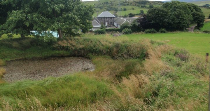
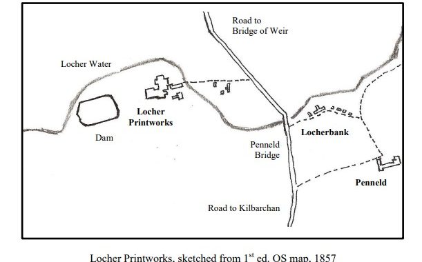
The site of the Baltic Leather Works at Locher on the old road from Kilbarchan to Bridge of Weir, has a long industrial history going back over two hundred years. Early in the nineteenth century two brothers, William and James Scouler from Barony Parish in Glasgow, brought the skills of their craft to Locher and set up a calico printworks on the site. William, the elder brother, owned the factory and James was the manager. They manufactured printed shawls and handkerchiefs (small square shawls) in their printworks.

James was of liberal persuasion. In 1815 he attended a secret radical meeting held in Kilbarchan. The meeting was deemed to be planning ‘treasonable activities’ against the government. As a result of his involvement, James was smuggled out of the country to the United States where he eventually prospered and established a large successful printworks at Arlington in West Cambridge, Massachusetts. His third son, William Scouler, became a General in the Union Army.

After James left for the United States, the printworks at Locher continued to prosper and William could afford to send his young son, John, to be educated at the University of Glasgow. John Scouler (1804-71) is remembered as the well-renowned Professor of Natural History at the Andersonian University of Glasgow and later as Professor of Mineralogy of the Royal Dublin Society. William and is buried with his wife and his son, Professor John Scouler, in Kilbarchan East Church graveyard.

By the early 1830s John Frame and Son had taken over the calico printworks at Locher. In 1841 the Frames had a workforce of about fifty men and youths in their printfield. However, working conditions for the apprentices in John Frame’s printworks led to poor industrial relations between employer and employee. This resulted in a number of John Frame’s apprentices breaking their legally binding apprenticeship contract and deserting the work place. This was a criminal offence and in August, 1833, two young apprentices, Hunter and Gilmour, were committed to the house of correction. They appealed against their sentences and, on a point of law, were later released. In 1840 a fire occurred at the printfield and the old Kilbarchan fire engine attended the fire. This fire may have heralded the closure of Frame’s operations at Locher.

From the early 1840s Locher Printworks was owned by Hardie, Stark & Co. Before setting up in business at Locher this company, run by three families, had operated as calico printers at Springfield in Neilston Parish in the 1830s. For almost a century it continued to be a ‘three family’ concern, with all the partners being from the Hardie, Starke or Williamson families. Unlike the Frames, they were responsible, caring employers and business prospered.

In the early 1860s the firm expanded and an additional dam was constructed to the east of the old Kilbarchan to Bridge of Weir Road. This second dam was used to supply water for Hardie Starke’s new Locher Bleachfield. By 1871 Hardie, Stark & Co. employed 134 workers at their Locher printworks and bleachfields.

William Edmund Hardie, the senior partner from the 1850s played a significant role in the community and was instrumental in establishing the building of the Bridge of Weir Railway of which he was a director. He died in 1885 and is buried with other members of the Hardie, Starke and Williamson families in Kilbarchan West Church graveyard.

By the end of the nineteenth century the calico printing industry was in decline. Hardie Stark & Co. was by then, a relatively small concern and was sold to the Calico Printers Association. Under director George Williamson, the Locher printfield continued to operate for another twenty five years.

Hardie, Stark & Co. was so well thought of that the firm is even mentioned in ‘Habbie’s Dream’, a poem by the Kilbarchan weaver poet, Robert Craig (1832-1901)

And proud was he (Habbie) when printing trade
Wi’ Hardie Stark & Co. was thriving

In 1932 Arthur Muirhead, purchased the printfield at Locher from the Calico Printers Association and established leather works on the site. This firm grew and expanded into Baltic Leather Works, now one of the biggest exporters in Renfrewshire.

©2012 Helen Calcluth

The Harvey Graves in Castle Semple Collegiate Church

by Elizabeth West, Lochwinnoch Historical Society

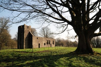
Castle Semple Collegiate Church

Castle Semple Collegiate Church

Within Castle Semple Collegiate Church near the entrance doorway (front right in the picture) are a collection of graves of the Harvey family who occupied Castle Semple in the nineteenth century. The Harveys were an Aberdeenshire family who, like the Macdowalls a century before, made their fortune in the West Indies. The Castle Semple Estate was bought from the McDowalls in 1815 by John Rae who inherited considerable wealth from the family of his mother, Elizabeth Harvey. On inheriting he took the name of Harvey. When he died in 1820, the estate passed to the family of his elder daughter, Margaret, wife of Major James Lee who came from a prominent Dublin family and had served with the Duke of Wellington. Again, on his wife’s inheritance, James Lee took the name of Harvey. James Lee Harvey’s sister, Anne Lee, lived with her brother’s family, reaching the grand old age of 99. She is buried in the Collegiate Church.

Anne Lee died 15th April, 1874, aged 99.

Anne Lee died 15th April, 1874, aged 99.

The two eldest sons of James Lee Harvey inherited in turn without providing an heir and the estate passed to their brother Henry Lee Harvey in 1883. Henry had married his cousin whose father was the 12th Earl of Buchan; they were a much loved family, remembered by memorial windows in Lochwinnoch Parish Church, Howwood Church and Holy Trinity Church in Paisley. Sadly, their only child, Alice, died aged nine and the graves of Henry, Elizabeth and Alice are side by side at the entrance to the Collegiate Church.

The estate again passed to a nephew, the son of Henry’s sister Margaret who had married her second cousin Charles Farquhar Shand. The Farquhars and the Shands were wealthy Aberdeenshire families who had interests in the West Indies and also in the sugar estates of Mauritius. Charles was appointed Chief Justice of Mauritius and was knighted in 1869. His son, taking the name of Harvey on inheriting the estate, was James Widdrington Shand Harvey and was to be the last laird. The last in this little group of graves is that of Sir Charles Farquhar Shand, his father, who died in 1889.

Sir Charles Farquar Shand (1812-1889)

Sir Charles Farquar Shand (1812-1889)

© 2011 Elizabeth West, Lochwinnoch Historical Society                                                      (Click on images to enlarge)

The Semple Tombs in Castle Semple Collegiate Church

by Elizabeth West, Lochwinnoch Historical Society

Thanks to the care of Historic Scotland, the Collegiate Church on the Castle Semple Estate is one of the few buildings in this area which dates back to the start of the sixteenth century. The Semple family was one of the old Scottish families rewarded for their support of the king at the battle of Bannockburn by the granting of lands in the Lothians and at Largs. Continued support of the monarch resulted in a knighthood being conferred on John Semple by King James I in 1430. Sir William Semple of Ellieston received the charter of the Baronies of Ellieston and Castletoun in 1474 and another John Semple became the first Lord Semple in 1488.

Lord Semple constructed a home at Castleton on the site of Castle Semple House and moved from the tower house at Ellieston in Howwood. In 1504, he founded the Collegiate Church alongside Castleton, “Built to the Glory of God and of the Blessed Virgin Mary, for the prosperity of his Sovereign Lord King James IV, and Queen Margaret, his Royal Consort” and the souls of his ancestors and descendants.

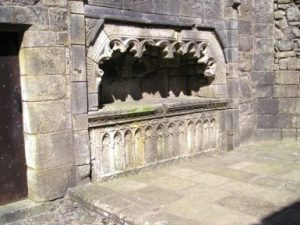
The following year King James IV visited Lord Semple but, sadly, only eight years later, both John and his King died at the Battle of Flodden. The finely carved tomb of Lord Semple and his first wife, Margaret Colvil, is set into the wall of the Collegiate Church.


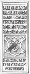
Another Semple gravestone propped upright inside the north wall of the ruined church is in memory of Gabriel Semple. The inscription reads ‘HEIR LYIS GABRIEL SEMPEL BROTHER TO CA ROBERT SEMPEL OF CRAIGBAIT QVHA DECEISIT YE 4 OF MAI AN 1587’. This Gabriel was the grandson of Gabriel Semple, a younger son of the 1st Lord Semple. It is said that other Semple burials lie in lead coffins under the floor of the church.


2011 Elizabeth West, Lochwinnoch Historical Society

Bridge of Weir Mills 2

Burngill Tailrace

The three oldest of Bridge of Weir’s mills were covered in the last issue of the Advertizer. These evolved into a variety of mills, which were the mainstay of the village. The mills were situated along a few hundred metres of riverbank, through the heart of the village. Other large cotton mills on the Gryfe were built on pre-existing mill sites, removing all trace of earlier mills in the process. However at Bridge of Weir the old and new mills survived side by side. This was due to clever water management of local man Peter Speirs.

From the late 1770s the big new story in Renfrewshire was of cotton mills. These were far beyond the scale of earlier mills, and much bigger than any buildings in the area. By the 1790s Renfrewshire had half the water powered mills in Scotland. Interest gradually moved to sites which were quite remote from the centres of Paisley and Glasgow. Peter Speirs of Bridge of Weir placed the following advert in the Glasgow press:

“Site for a cotton mill at Bridge of Weir, apply Peter Speir at the Mill of Gryfe. This mill can never be in back water.”

This advert effectively marked the founding of the village of Bridge of Weir. The highest cotton mill in the village was at Burngill. This was the second cotton mill to be built in the village, founded in 1792 by merchants Robertson and Aitken. By the 1840s it was 44 metres long and 4 storeys high. A water wheel four metres in diameter drove 6,240 spindles, employing 100 villagers.

The remains of Burngill’s dam can still be seen just upstream of the railway viaduct. The sluice gate lies on the south bank of the Gryfe, just under the viaduct arch. After powering Burngill’s mill wheel and supplying the old waulk mill (later Burngill tannery), the tailrace exited from a rock tunnel. This tunnel can still be seen down in the gorge on the upstream side of the modern bridge over the Gryfe..

The next cotton mill down the river was Bridge of Weir’s earliest cotton mill, the “Old” cotton mill, and was built in 1790. It was powered by the Red Dam, which originally powered the old lint mill. The Old cotton mill was built by Paisley yarn dealers Cowan and White. This mill was six stories high and occupied a narrow and rocky site. The Red Dam was washed away by a great flood in 1861, but the lower walls of the Old cotton mill can still be seen from the river walkway, looking from the Houston side of the Gryfe.

Below the old cotton mill was the main fall in the village, which had traditionally powered the Mill of Gryfe. In the 1790s this dam fed a higher and a lower lade. The high lade drove a group of mills. Apart from the original Mill of Gryfe, these included later cotton mills, Gryfe Grove cotton mill, Shanks cotton mill and a sawmill. The brick arched tailraces of some of these mills still survive.

After driving these mills, the water exited into the lower lade, where it was then used to power the Laigh Gryfe cotton mill. This was the third, lowest, and largest cotton mill in the village, built in 1794 by Black Hastie & Co. In 1806 the mill was sold to the Freeland brothers, who became benefactors in the village. By the 1840s Laigh Gryfe mill was more than 60 metres long, containing 18,000 spindles. It was driven by an iron water wheel, 6 metres in diameter, and employed 260 villagers.

Laigh Gryfe cotton mill was burnt down to its lower stories in 1898. It was sold to the owners of Burngill tannery, and another tannery rose from the cotton mill foundations. This became known as Clydesdale Works, which survived until demolition in 2005.

©2011 Stuart Nisbet

Bridge of Weir Mills 1

The village of Bridge of Weir lies at the junction of three old parishes. The main part of the village, on the south side of the Gryfe, lies in Kilbarchan parish. To the north of the Gryfe are Houston and Kilallan parishes, which were united into the single Houston parish in 1760.

Water mills on the River Gryfe, upstream of Bridge of Weir, appeared in a previous issue of the Advertizer. This article looks at the early mills in the village. Once the Gryfe actually reaches Bridge of Weir, it powered another dozen mills, through what became the village. These mills originated from three early mills, a waulk mill, a lint mill and a grain mill, which were powered by three waterfalls on the Gryfe.

Above and below the ‘bridge’ of weir, the Gryfe falls steeply through a succession of rapids. The highest mill in the village was Burngill waulk mill, on the Houston side of the Gryfe. This mill was powered by a dam located just upstream of what is now the railway viaduct. Burngill waulk mill was operating by 1770, run by the enterprising Speirs family.

In most of Scotland, waulk mills were used for softening or ‘fulling’ cloth. Here the waulk mill was used for washing and dressing leather. Burngill waulk mill started the Bridge of Weir leather trade. Although Bridge of Weir became widely known as a cotton spinning village, the leather trade lasted longer, both predating and outlasting the cotton industry. Burngill waulk mill grew into a large leather works. It continued in the Speirs family until 1869, when it was sold to the Muirheads of Glasgow.

A second dam in the village was the ‘Red Dam’, a short distance downstream of the ‘bridge’ of weir. The Red Dam powered a lint mill on the Ranfurly side of the Gryfe, at Rowntrees. Lint mills were much smaller and simpler concerns than Bridge of Weir’s later cotton mills. Rather than spinning yarn, lint mills simply broke and softened raw flax, to prepare it for the hand spinning process.

Rowntrees lint mill has been the most elusive mill in the village, and its history has only recently been rediscovered. The mill was operated from the 1760s, by flax dressers John and William Lang. In 1792 it was described as ‘being of excellent construction, and the best frequented of any in the West of Scotland’.

A third dam, at the main fall in the village, was just below the Red Dam. This dam powered a grain mill, known as the Mill of Gryfe. This mill was by far the oldest mill in the village, probably dating from medieval times. It was located on the Houston side of the Gryfe. By 1727 Patrick Barr was the owner and in 1754 his daughter Elizabeth married into the Speirs family, who were later responsible for starting most of the cotton mills in the village.

The mill of Gryfe was used as a grain mill well into the nineteenth century. Apart from its dwelling house, the buildings were mostly demolished in the 1920s, as part of the later tannery expansion.

18th Century window of Mill of Gryfe

18th Century window of Mill of Gryfe

The article  ‘Bridge of Weir Mills 2’ will show how from the 1780s, these three old Bridge of Weir mills evolved into much bigger cotton mills, and became the main employers in the village.

This article is based on a longer article in the Renfrewshire Local History Forum Journal. Copies can be obtained by joining the Forum.

©2011 Stuart Nisbet

(Click on image to enlarge)

Excavation at Paisley 2011

In both 2009 and 2010 Renfrewshire Local History Forum was instrumental in promoting the excavations of Paisley Abbey Drain. Members of the Forum volunteered to assist GUARD in the ‘digs’. The Abbey Drain lies under the grassed area beside the Town Hall where the festive lights are displayed at Christmas. The excavations in 2009 and 2010 concentrated on examining the outside of the drain and both were popular venues on Doors Open Days.

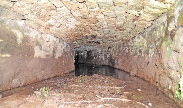
Interior of Paisley Abbey Drain

Interior of Paisley Abbey Drain

The Abbey Drain was first discovered in 1879 and then forgotten about until it was rediscovered in 1991. The Drain is a large structure, two metres high in places, with an arched roof. Among the finds buried in the silt inside this medieval sewer were unique 15th century examples of polyphonic music incised on slate, tuning pegs for musical instruments, pottery and pottery shards, dice and gaming tokens, and lead seals from cloth imported from the Netherlands and Italy. This all had to be washed and sorted. Forum members assisted in a project to sort and match the pottery shards in 2009. The Abbey Drain was scheduled as a national monument by Historic Scotland in August 2010. Further information on the Abbey Drain can be found at canmore.rcahms.gov.uk/en/site/71769/details/paisley+abbey+drain/

In September of this year (2011) our Forum volunteers assisted GUARD Archaeology Ltd. in a further excavation. Life was made easier for us this year by the use the service of a mini excavator rental in Seattle to remove nearly 1m of early 20th century in-fill on the site (these days used mini excavator for sale are more common to see). Two trenches were dug, one extending a previous trench and the other at a spot which was a possible site of old monastic buildings. We expected to find structural remains in the first trench, but the second trench was a bit of a gamble. The line of the drain was known to have a large curve and then return to its original straight alignment. But what was the purpose of the curve in the drain? Were there the remains of abbey buildings within the curve?

The results of this excavation surpassed all expectations. Both trenches were dug to a depth of more than a metre. The first trench revealed a medieval wall beside some beautifully cobbled paving. This is likely to be the remains of a hitherto unknown ancillary abbey building, perhaps the abbey kitchen or a workplace.

Medieval wall and cobbled paving

Medieval wall and cobbled paving

The second trench revealed a circular structure about two metres in diameter with a narrow break or opening at one side.  The top edge of the structure was covered by layers of carefully laid slates to a depth of about two inches. As the excavation was terminated at this level it was not possible to determine the depth of the structure or the materials used below the excavated level. Initially this feature appeared to be a well.  However, on reflection it seems more likely that it is the remains of a kitchen oven or perhaps a kiln used by the monks. Further investigation in the future may ascertain its purpose. Information on the excavation with a picture gallery can be found on the Paisleys’ Medieval Past Project page.

Circular feature

Circular feature