The Barmufflock Mystery

Barmufflock Dam

Previous articles in the Advertiser have looked at mills on the Gryfe at Bridge of Weir. These ranged from small rural grain, waulk and lint mills, to much larger cotton mills, which were the origin of the village. By 1815 Bridge of Weir’s cotton mills employed most folk in the growing village and surrounding area.

As the mills were powered by water, their economic survival, and the prosperity of the village depended on a constant flow in the River Gryfe. This was acknowledged in the ‘town rhyme’, which was read out at all local events through the nineteenth century:

‘May the River Gryfe
Flow on through life,
And ne’er be wanting water;
May Bridge of Weir town
Rise in renown,
And aye be growing better’.

The mill owners were obsessed with conserving water to such an extent that the times of the meal breaks in the successive mills were staggered downstream, and their sluices opened and closed in succession.

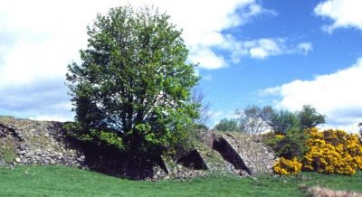
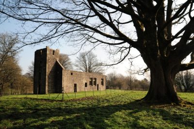
To provide extra water for times of drought, the biggest cotton mill, the Laigh Mill, built its own reservoir, Houstonhead Dam, which fed into their lade directly above the water wheel. However this dam was too far downstream to benefit the two highest cotton mills, the Old Cotton Mill and Burngill Cotton Mill. In 1815 the three cotton mills jointly formed a plan, the “Barmufflock Agreement”, to create a new reservoir for the benefit of them all. The dam was built high above Bridge of Weir, on the headwaters of the Pow Burn, above Lochend Farm.

There was one snag – the Pow Burn entered the Gryfe below three of the mills, at the foot of Mill Brae, and would only have benefited Crosslee Mill, whose dam was further downstream. The solution was to build a lade, diverting the Pow Burn into the Gryfe above the highest mill.

Half-way down its course, the Pow Burn was diverted at Clevans Road, just above what is now Ranfurly Castle Golf Course Club House. It followed the line of modern Barrcraig Road, then fell steeply down towards the Gryfe, passing under Torr Road and entering the Gryfe upstream of what is now the railway viaduct. As the cotton mills differed in size, their contribution to the Barmufflock scheme was based on their respective number of spindles. The reservoir had another use, as a popular curling venue. When the cotton mills closed in the 1870s the dam fell into disuse.

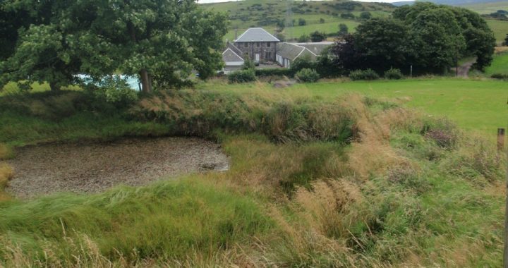
At the same time, the Pow Burn became a source of drinking water for the village. An initial scheme was completed in 1881 and fed into tanks at Donaldfield. In 1900 another dam was built in the headwaters of the Locher Water at Ladymuir, with pipes laid down to Donaldfield.

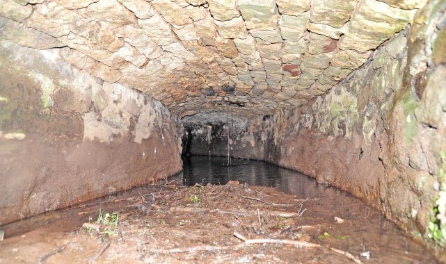
Barmufflock Dam (see image above) fell into disuse and was drained by 1913. The boggy site became well known by naturalists as a home of rare plants. The massive rubble dam still survives and the lade can be traced down through the village to the Gryfe.

© 2013 Stuart Nisbet

Welcome

Welcome to our new website.  We have added some new sections to the website, including Local History Articles, and by the end of the year we hope to have added all of the articles from the Journal.

A Village Co-op (Kilbarchan)

Older residents in Kilbarchan will remember with some nostalgia the Kilbarchan Co-operative Society. Its shops were the equivalent of a supermarket on the doorstep. Unlike modern supermarket stores, the various departments, all conveniently within walking distance, were situated throughout the village. The ‘High Co’ was in New Street, the ‘Low Co’ was in Low Barholm and the dairy, the butcher’s shop and the drapery were in High Barholm, where the present-day co-op convenience store is situated. The ‘Low Co’ and the ‘High Co’ stocked a wide range of groceries. While the customer waited, dried goods were carefully weighed and supplied in brown paper bags. Butter, taken from a wooden barrel, was carefully weighed and shaped with wooden butter pats into useable small blocks. The co-operative shops afforded a relaxed and sociable atmosphere where village customers and shopkeepers could pass the time of day and catch up with local affairs and gossip.

The co-operative movement began in Rochdale in 1844 when the Rochdale Society of Equitable Pioneers, with a membership of thirty tradesmen, including ten local weavers, set up a consumer co-operative grocery store where consumers were paid a patronage dividend. The movement rapidly spread. Ten years later there were almost one thousand co-operatives in Britain. But how did it begin in Kilbarchan?

An early non-dividend co-operative was run in Kilbarchan by village Chartists in the 1850s, but this was not run on Rochdale lines and was short-lived. In 1872 Kilbarchan Co-operative Society, run on the Rochdale principles, was started in a weaving shop in New Street. A few years later another co-operative was established at 36 High Barholm, but it soon got into financial difficulties and was taken over by the New Street co-operative in the 1880s. By 1899 the Kilbarchan Co-operative Society was thriving with two grocery shops in the village – a central store at No.4 New Street, run by Robert Hart and a branch at No.1 Low Barholm, run by John Miller.

In the nineteenth century the Co-operative was regarded not just as a retail outlet but, officially in Parliamentary Papers, also as a Friendly Society. As well as paying dividends, Kilbarchan Co-operative Society organised annual excursions for its members. In 1885 the excursion to Ardrossan was accompanied by Kilbarchan Instrumental Brass Band. Another excursion went to Rothesay. In 1886 Malcolm Neil, a prominent co-operator in Kilbarchan, was elected as a director of the Scottish Co-operative Wholesale Society. However, Malcolm Neil is better remembered as one of the joint pursuers in the famous Kilbarchan Right-of Way case.

Kilbarchan Co-operative Society continued to prosper. In 1904, the society bought 1216 square yards of ground bounded by Well Strand from Richard Hunter of Glentyan Estate. A new two storey building was erected on the site in High Barholm. By 1910 this building, with four flats in the upper storey, housed the co-operative’s Fleshing Department run by David Murphy and its Drapery and Boot Department run by Christina Gibson. Also, a co-operative Coal Department, run by Colin Lind, had been established at Milliken Park Station. All this was in addition to the New Street and Low Barholm grocery stores. By 1912 further expansion added a dairy in the High Barholm building. The administration of the business was run by a committee of local men who acted as president, secretary and treasurer.

By 1975, more than a century after the founding of the Kilbarchan Co-operative Society, the shops in High Barholm and New Street, under the ownership of Paisley Co-operative Manufacturing Society, were still serving the village, but the ‘Low Co’ had closed.

© 2012 Helen Calcluth

Two Castles – One Name: Johnstone or Easter Cochrane Tower

The three-storey stone tower which lies in Johnstone Castle housing estate is one of the few surviving castles in Renfrewshire. It is also the most confusing. To understand it, we need to ignore modern place names and go back 400 years to two estates, Johnstone and Cochrane, one on each side of the Black Cart Water.

The first estate, on the north side of the Black Cart, in Kilbarchan Parish, was what we will call ‘Old’ Johnstone estate. Old Johnstone was traditionally owned by the Wallace family. They had one of the biggest castles in Renfrewshire, which is sketched on Timothy Pont’s surveys in the 1580s. In the early 1600s, Old Johnstone was purchased by a branch of the Houstons of Houston, who became the Houstons of Johnstone. They became important in Kilbarchan parish and had a family aisle in Kilbarchan Kirk.

The second estate lies on the south side of the Black Cart, in the Abbey Parish, known as Cochrane Estate. In the early 1500s, Cochrane was split into Easter and Wester Cochrane. The part of interest to us is Easter Cochrane, which included the lands of Quarrelton, Hag, Greenend and Cartside. At its heart was a tower house called Easter Cochrane. By the late seventeenth century, Easter Cochrane was owned by an old Renfrewshire family, the Porterfields, who sold it to the Houstons of Johnstone. This made the Houstons owners of estates on both sides of the Black Cart in this area. In 1730 ‘Old’ Johnstone was purchased by McDowall of Castle Semple, on behalf of his friend James Milliken, a sugar planter about to return from the Caribbean. On his return, Milliken demolished the old castle of Johnstone, building Milliken House nearby, and renaming the lands north of the Cart as Milliken Estate, after himself.

Thereafter, George Houston of Johnstone concentrated his efforts on his remaining estate of Easter Cochrane, south of the Black Cart, which was rich in coal and lime. Easter Cochrane tower became Houston’s residence, and adopted the ‘Johnstone’ name, effectively switching the name ‘Johnstone Castle’ from the north to the south of the Black Cart, from the great castle which had stood on what was now Milliken estate, to the more modest tower which survives at Easter Cochrane. The switch of the Johnstone name from the north to the south of the Black Cart was reinforced when Houston of Johnstone commenced the planned town of Johnstone on Easter Cochrane land from the 1780s.

The earliest sketch of Easter Cochrane tower was on Pont’s survey of the 1580s. By the 1730s, John Watt showed it as a central tower with two wings, a walled garden to the rear, and a long tree lined avenue heading north. To the south was the steading or fermtoun of Quarrelton. The tower was surrounded by coal and lime pits, and a reservoir on the Craigbog Burn, which powered a water powered engine to drain the mines. By the 1770s, Houston had converted this engine from water to steam power and the reservoir became an ornamental pond, then disappeared.

The house was altered and extended several times, including alterations in 1812 possibly by architect James Gillespie Graham. By the Victorian period, the old tower had turned into a grand castellated mansion, which retained the ‘Johnstone Castle’ name. The surrounding area became landscaped parkland, with only the numerous old coal pits to hint at the source of Houston’s wealth. Careful study of surviving photos of the mansion reveals the old tower still embedded in its heart. By the 1940s, the castle was in the centre of an army camp, surrounded by rows of corrugated huts. The camp had various uses, initially holding Polish soldiers, then as a prison of war camp, and finally as housing for returning British servicemen. By the 1950s the mansion was in ruins and demolished. The part comprising the old tower was saved, leaving it as it stands today, but with the ‘wrong’ name.

The story doesn’t end with this tower. A short distance to the west stands a prominent hillock, ringed by old estate paths, now hidden by woods. In the 1730s this mound was named ‘Castle Hill’ – perhaps the predecessor of Johnstone Castle, alias Easter Cochrane?

In September 2006, Renfrewshire Local History Forum carried out a small excavation at Johnstone Castle as part of Scottish Archaeology Month and Renfrewshire Doors Open Day.

Johnstone Castle excavation 2006

Johnstone Castle excavation 2006

© 2012, Stuart Nisbet                                                                                   (Click on image to enlarge)

Robert, 3rd Lord Semple

Robert, 3rd Lord Semple, (c. 1505-1573) was known as The Great Lord Semple. He lived in unsettled, violent times and was involved in on-going local feuds, battles between Scotland and England and religious conflict within Scotland engendered by the reformation. As a young man, Robert fought in numerous skirmishes with local families. These often entailed criminal offences such as reiving, spoliation and even murder, but perpetrators as influential and powerful as the Semples were seldom called to account.

After the death of King James V in 1542, Mary, his six day old daughter, became Queen and Scotland was ruled for some years by regents. Robert Semple was a staunch supporter of the House of Stuart and frequently attended court. A Catholic by faith, he seems at times to have found it politically expedient to give some tacit support to Protestant views. In 1544 Robert had a violent skirmish with two monks in the Paisley Abbey because he wanted ‘adequate cautioners’ (verification of authenticity) for the relics and ornaments held in the St Mirin Aisle. However, this action was not regarded as untoward, apparently, for in April of the following year he was granted by charter the Bailliary of Regality of Paisley for defending the monks of Paisley Abbey from heretics and tyrants.

Another more serious incident occurred in 1550, when in a heated argument at a gathering of nobles in the house of the Regent in Edinburgh, Robert Semple, who was said to have been supporting the new religion, became so incensed that he drew his dagger and stabbed William, 3rd Lord Crichton of Sanquhar, through the heart. With help of influential friends his death sentence for this murderous offence was reduced to a contract to pay compensation to Lord Crichton’s family.

On the international scene, conflict between England and France led Henry VIII to declare war on the Scots to force a marriage between his son Edward and the infant Mary Queen of Scots. The ensuing war was known as The Rough Wooing (1543-1550). In 1547 Robert fought at the Battle of Pinkie and, despite a rescue attempt by his friends, was taken prisoner by the English.

In the 1550s Robert, now 3rd Lord Semple and a staunch supporter of Mary of Guise, decided to build a fortified tower where his family and retainers could find refuge from the threat of marauding local or government attackers. This defensive structure, known as the Peel Tower, was built on a small rocky island on Castle Semple Loch. In October, 1560, the 2nd Earl of Arran, besieged the Semple castle. Held up for a week by violent storms, the Earl eventually set up his artillery and attacked the castle. The next day, the gatehouse tower fell and the castle was surrendered on the following day. Semple’s son was taken prisoner and the Semple Castle and Peel Tower were occupied by Arran’s forces.

Remains of the south wall of the Peel Tower today

Remains of the south wall of the Peel Tower today

However, in 1567 after the murder of Darnley, Queen Mary’s husband, Lord Semple changed sides. He fought against the Queen’s forces at the Battle of Carberry Hill in that year and at the Battle of Langside in 1568, when Mary was defeated and subsequently fled to England. He was appointed Commendator (the secular equivalent of Abbot) of Paisley Abbey and was a member of Regent Moray’s secret council. However, after Moray was murdered in 1570, Semple was captured by the Hamiltons and imprisoned in Argyll for a year in the custody of Lord Boyd.

peel tower1Robert, the Great Lord Semple, died around 1573, most probably at Castle Semple in Lochwinnoch. Although no evidence of his burial stone exists today, a drawing of part of a complete stone (c.5 x 2 feet) which lay in Lochwinnoch Churchyard in the late 19th century shows the Semple Arms and the initials of Robert, 3rd Lord Semple and his first wife Isabel Hamilton. No date or other inscription appeared on the stone. The Great Lord Semple certainly was strong, influential and powerful and could endure hardship – but was he really ‘Great’?

© 2012 Helen Calcluth (Click on images to enlarge)

Renfrewshire a Scottish County’s Hidden Past

The book launch by Derek Alexander of ‘RENFREWSHIRE a Scottish County’s Hidden Past’ was held in Waterstone’s in Braehead on the 14th of June. Derek Alexander and the late Gordon McCrae, are co-authors of the book. In his address at the book launch Derek read some excerpts from the book and expressed his hope the book would encourage others to look for Renfrewshire’s ‘hidden past’.

renfrewshireDerek is the Head of Archaeological Services for the National Trust for Scotland and has been an active member of Renfrewshire Local History Forum for many years.

Gordon was a noted local historian and studied archaeology at Liverpool University. Past students of Paisley University (the University of the West of Scotland) will remember him as its Depute Librarian.

Gordon was a founder member of Renfrewshire Local History Forum in 1988. His passion for local history and archaeology and unbounded enthusiasm is almost legendary. He organised and led numerous Forum field trips round the county, liberally sharing his extensive knowledge – and boiled sweets! His sudden death in 2005 was a tragic loss to the Forum. This book has been dedicated to his memory.

The book covers archaeological sites in Renfrewshire, East Renfrewshire and Inverclyde from the Palaeolithic to Early Modern Times. The archaeological sites are set within their historical context and the book is illustrated by more than one hundred maps, plans and illustrations.

Many local sites, in or near the villages where the Gryffe Advertizer is distributed, are covered in the book. These include, among others, Castle Semple Estate and the Collegiate Church at Lochwinnoch, Whitemoss and Barochan Roman forts near Bishopton, the excavation at South Mound in Houston, the late Bronze Age homestead at Knapps, Duchal Castle near Kilmacolm, the mote hill on Old Ranfurly Golf Course in Bridge of Weir, a moated manor and enclosure near the Wallace Monument in Elderslie, the crannogs in the Clyde at Langbank, Elliston Castle and the Midton Lime Kiln at Howwood, and excavations at the Old Churchyard and the Weaver’s Cottage in Kilbarchan.

For those interested in the seeking out archaeological evidence for the history of Renfrewshire, ‘RENFREWSHIRE A Scottish County’s Hidden Past’ is an excellent resource. For the many walkers who roam around our local area, the information in the book will provide additional points of interest in their walks. ‘RENFREWSHIRE A Scottish County’s Hidden Past’ (published by Birlinn Ltd.) can be obtained from Renfrewshire Local History Forum as well as from commercial booksellers.

© 2012 Helen Calcluth

Little Kaimhill Cottage

Kaimhill Cottages were built on the site of the former farm steading of West Kaimhill. Both cottages were built in a style common to the agricultural cottages in 19th century Scotland. They were situated in an acre of ground between Kaimhill and Coalbeg Farms to the north of the road from Locher Bridge to Crosslee. The main building consisted of two cottages abutting each other, with various additions built on at later dates.

The original occupant of the first cottage to be built was John Barr, late of the adjacent farm of Coalbog. Perhaps making a career change from farmer to builder, James Barr ‘seized’ (took possession of) in June, 1801, an acre of ground with the houses thereon being part of the lands of Kaimhill called Coalbog. These old farm buildings may have been deemed only suitable material for dismantling and for re-use in the construction of the improved steading buildings then being erected.

John Barr appears to have worked as a mason for some years and later became overseer at Craigends. He continued in the Cunninghames’ employ till March, 1827, when he retired to his cottage at Little Kaimhill. He died in the 1830s and was buried in Kilbarchan East Church graveyard. His wife, Mary, aged 75, still lived in the cottage in 1841.

The next occupants of the cottage in the first half of nineteenth century were coalminers. John Craig was probably employed in the coal pits being worked in conjunction with the nearby lime works by the side of the Gryffe. About 1845 John McGilchrist, a coal and lime master from Balgrogan, Campsie in Stirlingshire moved to Bridge of Weir and lived in the cottage with his wife and six children He became a local coalmaster, probably operating Kaimhill Coal and Limeworks from then until 1859, when it closed and he returned to Campsie.

The 1861 census for Kaimhill had the first notification of two cottages on the site. One cottage was of one room only and was occupied by James Livingston, a retired farmer aged 82, and his wife and son. The other cottage had two rooms and was occupied by William Woodrow, age 36, a grain miller from Kilbarchan, and his wife and family. Later James Stevenson, a carter from Kilbarchan, and his family occupied the larger cottage before moving to Barnbeth where the Stevensons of Barnbeth ran a potato merchants business from a yard in Church Street in Johnstone until 1881.

By 1881 both cottages had been extended. Hugh Wallace, a mason who had owned a building business in Hill Street, Kilmarnock in the 1860s, moved to Kaimhill in 1873. He is a likely candidate for the person who carried out at least some of the substantial changes to the cottages between 1871 and 1881. Sadly, he died in unfortunate circumstances in 1883. He was last seen in Bridge of Weir village on his way home and is supposed to have had a considerable amount of money in his possession. Some days later his body was found in the River Gryffe near a ford. As he was a prosperous man he is an unlikely candidate for suicide. Perhaps he was making his way home via the ford and lost his footing.

Later occupants of the cottage at the end of the century included George McKenzie, a painter and photographic artist, William Lee, a retired farmer, and Hugh Keith, a railway contractor, who died at Kaimhill in 1925. The cottages remained in the possession of the Keith family for another 50 odd years.

© 2012 Bill Speirs,  Johnstone History Society and RLHF

The Forgotten Past of a Renfrewshire Farm

High Mathernock, seen here from its reservoir, replaced the earlier farm and settlement which were situated much closer to the Water of Gryfe

The village of Kilmacolm is surrounded by farms with names which go back at least as far as the sixteenth century and possibly to early mediaeval times. High Mathernock, on the north side of the Gryfe Water, is one of those farms whose forgotten history involving milling as well as farming is gradually coming to light.

The modern farm at High Mathernock has stood in its present location since the 1830s and was built in stages by the Shaw Stewart family for the tenant John Lang. Earlier activity at Mathernock, however, took place closer to the Water of Gryfe.

When Timothy Pont surveyed Renfrewshire in the sixteenth century he considered Macharnoch, the waulkmill, and Macharnay (possibly an older name for the nineteenth century Low Mathernock) significant enough to be mapped. All that remains of Pont’s Macharnoch which probably lay just north of Mathernock Bridge is possibly the few courses of stone wall low down on the river bank where, according to folk memory, there was a corn mill. There are two records of a corn mill on the site, one in a record of the Scottish Parliament in 1670, the other in a book about Renfrewshire written in 1782 which states that formerly there was a corn mill there. Further downstream on the other side of Mathernock Bridge lie the probable remains of the waulkmill in the form of a dam to deflect the water course, a partly silted up lade and the remains of walls. The still thriving patch of very old sloe bushes could have used in the dyeing process.

Eighteenth century records show a thriving community at Mathernock involved in a wide variety of occupations. The earliest Kilmacolm Parish Records up to 1745 don’t give occupations. However, in the second half of the eighteenth century we know that people made their living in a wide variety of ways e.g. living and working in Mathernock were a maltman, a smith, millers, farmers, a workman, a weaver, a dyster, a herd, a mariner, a ‘musiciner’ and many others whose occupations were not noted when they married or died. By the nineteenth century, all traces of milling and weaving had disappeared and the people of Mathernock were making their living as farmers and labourers, the principal farmers being the Langs.

Although many field boundaries have been erased by modern farming methods, there remain those which surround an irregular narrow enclosure running down a south facing slope towards the river. The farm of Low Mathernock lay here and before that the fermtoun of Mathernock. The footings and platforms of several buildings can be made out as can the line of the road between Kilmacolm and Port Glasgow, which can be seen on maps from the end of the seventeenth and beginning of the eighteenth centuries.

© 2012 Maggie Hancock and Jennie Hynd

The Semple Tombs in Castle Semple Collegiate Church

by Elizabeth West, Lochwinnoch Historical Society

Thanks to the care of Historic Scotland, the Collegiate Church on the Castle Semple Estate is one of the few buildings in this area which dates back to the start of the sixteenth century. The Semple family was one of the old Scottish families rewarded for their support of the king at the battle of Bannockburn by the granting of lands in the Lothians and at Largs. Continued support of the monarch resulted in a knighthood being conferred on John Semple by King James I in 1430. Sir William Semple of Ellieston received the charter of the Baronies of Ellieston and Castletoun in 1474 and another John Semple became the first Lord Semple in 1488.

Lord Semple constructed a home at Castleton on the site of Castle Semple House and moved from the tower house at Ellieston in Howwood. In 1504, he founded the Collegiate Church alongside Castleton, “Built to the Glory of God and of the Blessed Virgin Mary, for the prosperity of his Sovereign Lord King James IV, and Queen Margaret, his Royal Consort” and the souls of his ancestors and descendants.

The following year King James IV visited Lord Semple but, sadly, only eight years later, both John and his King died at the Battle of Flodden. The finely carved tomb of Lord Semple and his first wife, Margaret Colvil, is set into the wall of the Collegiate Church.


Another Semple gravestone propped upright inside the north wall of the ruined church is in memory of Gabriel Semple. The inscription reads ‘HEIR LYIS GABRIEL SEMPEL BROTHER TO CA ROBERT SEMPEL OF CRAIGBAIT QVHA DECEISIT YE 4 OF MAI AN 1587’. This Gabriel was the grandson of Gabriel Semple, a younger son of the 1st Lord Semple. It is said that other Semple burials lie in lead coffins under the floor of the church.


2011 Elizabeth West, Lochwinnoch Historical Society

Bridge of Weir Mills 2

Burngill Tailrace

The three oldest of Bridge of Weir’s mills were covered in the last issue of the Advertizer. These evolved into a variety of mills, which were the mainstay of the village. The mills were situated along a few hundred metres of riverbank, through the heart of the village. Other large cotton mills on the Gryfe were built on pre-existing mill sites, removing all trace of earlier mills in the process. However at Bridge of Weir the old and new mills survived side by side. This was due to clever water management of local man Peter Speirs.

From the late 1770s the big new story in Renfrewshire was of cotton mills. These were far beyond the scale of earlier mills, and much bigger than any buildings in the area. By the 1790s Renfrewshire had half the water powered mills in Scotland. Interest gradually moved to sites which were quite remote from the centres of Paisley and Glasgow. Peter Speirs of Bridge of Weir placed the following advert in the Glasgow press:

“Site for a cotton mill at Bridge of Weir, apply Peter Speir at the Mill of Gryfe. This mill can never be in back water.”

This advert effectively marked the founding of the village of Bridge of Weir. The highest cotton mill in the village was at Burngill. This was the second cotton mill to be built in the village, founded in 1792 by merchants Robertson and Aitken. By the 1840s it was 44 metres long and 4 storeys high. A water wheel four metres in diameter drove 6,240 spindles, employing 100 villagers.

The remains of Burngill’s dam can still be seen just upstream of the railway viaduct. The sluice gate lies on the south bank of the Gryfe, just under the viaduct arch. After powering Burngill’s mill wheel and supplying the old waulk mill (later Burngill tannery), the tailrace exited from a rock tunnel. This tunnel can still be seen down in the gorge on the upstream side of the modern bridge over the Gryfe..

The next cotton mill down the river was Bridge of Weir’s earliest cotton mill, the “Old” cotton mill, and was built in 1790. It was powered by the Red Dam, which originally powered the old lint mill. The Old cotton mill was built by Paisley yarn dealers Cowan and White. This mill was six stories high and occupied a narrow and rocky site. The Red Dam was washed away by a great flood in 1861, but the lower walls of the Old cotton mill can still be seen from the river walkway, looking from the Houston side of the Gryfe.

Below the old cotton mill was the main fall in the village, which had traditionally powered the Mill of Gryfe. In the 1790s this dam fed a higher and a lower lade. The high lade drove a group of mills. Apart from the original Mill of Gryfe, these included later cotton mills, Gryfe Grove cotton mill, Shanks cotton mill and a sawmill. The brick arched tailraces of some of these mills still survive.

After driving these mills, the water exited into the lower lade, where it was then used to power the Laigh Gryfe cotton mill. This was the third, lowest, and largest cotton mill in the village, built in 1794 by Black Hastie & Co. In 1806 the mill was sold to the Freeland brothers, who became benefactors in the village. By the 1840s Laigh Gryfe mill was more than 60 metres long, containing 18,000 spindles. It was driven by an iron water wheel, 6 metres in diameter, and employed 260 villagers.

Laigh Gryfe cotton mill was burnt down to its lower stories in 1898. It was sold to the owners of Burngill tannery, and another tannery rose from the cotton mill foundations. This became known as Clydesdale Works, which survived until demolition in 2005.

©2011 Stuart Nisbet