The Draining of Barr Loch: Canals and Tunnels

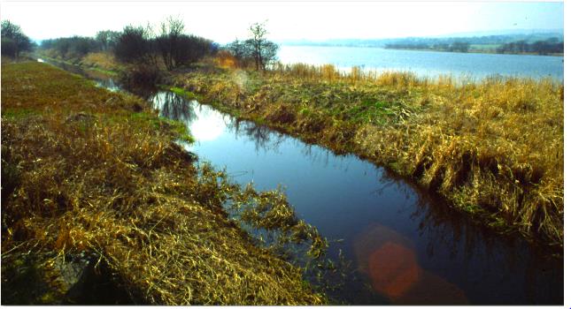
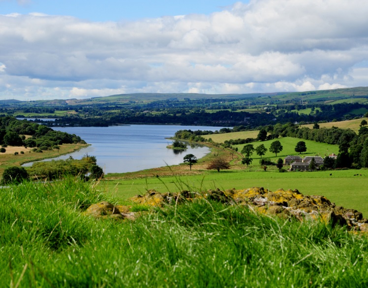
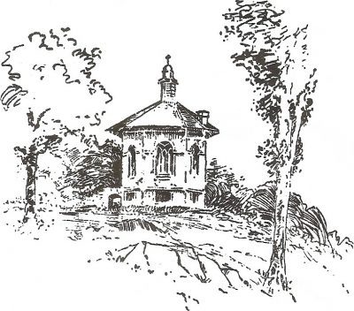
The final big drainage scheme was to drain Barr Loch, but keep Castle Semple Loch full of water. This scheme was the inspiration of another local landowner. In 1813, Adam of Barr purchased the whole of Barr Loch, plus about 100 acres of Castle Semple Loch. The first part of his plan was to dig a circular ditch, or canal, right round Barr Loch, ( see image above)  to prevent the water from the burns pouring in, and carry their water into Castle Semple Loch.

Outlet of Adam’s Drain at Eliston Bridge
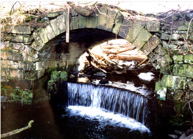
The second plan was to carry the water away from Barr Loch to the Black Cart down a canal which would bypass Castle Semple Loch. Adam started the lower end of his drain at the Black Cart near Elliston Bridge, where the outfall can still be seen.

The next 800 metres were in full view of Castle Semple House and had to be buried in a stone-lined tunnel. The tunnel then changed to the open canal which can still be seen following the south side of Castle Semple Loch. The canal connected to Barr Loch via a tunnel under the causeway which crossed the lochs. The scheme was carried out in 1814 by masons and Irish navvies. The water at the lowest point of Barr Loch, which was too low to drain away naturally, was raised from the loch bed up into the canal by a pump driven by a water wheel at Hole of Barr.

Although the works cost £10,000, the annual profit generated from oats and hay grown in the former loch bed, was about £1,500 a year, and the scheme paid for itself in a few years. Barr Loch had become ‘Barr Meadows’ and Adam’s scheme kept 170 acres of former loch bed dry and under crop for more than 131 years. One morning in 1946, locals were astonished to wake up and find that what had for generations been green meadows, was now a loch again. A lack of maintenance had led to the failure of the sluices and the turning of Barr Meadows back into Barr Loch.

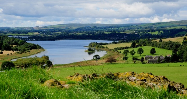
In future, the lochs are likely to remain safe from the whims of wealthy landowners, thanks to the establishment of the nature reserve and country park. However, when visiting Castle Semple Loch, it is worth remembering that at various times in the past it was possible in a dry summer, to walk across the loch.

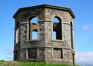
©2015, Stuart Nisbet, Renfrewshire Local History Forum                      ( Click image to enlarge )

The Draining of Castle Semple Loch

Around 13,000 years ago, all of Renfrewshire west of the Black Cart was an island in the Clyde, twice the size of Arran and almost as dramatic. It is a sobering warning of the potential effects of climate change, that a warm period between glaciations had raised sea level by around thirty metres. At that time, it was possible to sail through the Lochwinnoch Gap from what is now Paisley, west to the Ayrshire coast at Irvine. Today this seems ridiculous, yet the Eglinton family tried to do the very same thing with a canal, until their ambitions dried up at Johnstone, less than half way from Glasgow to the coast

Half way along the Lochwinnoch Gap lies Castle Semple Loch, a focal point of the country park of Castle Semple Country Park. Three hundred years ago Castle Semple Loch and Barr Loch were one single stretch of water, six kilometres long. The lochs are only two or three metres deep, and the ground underneath is rich in decomposed vegetable matter. From the 1680s, a number of ambitious engineering projects were carried out to drain away the water, and create hundreds of acres of fertile farmland. The first scheme was more than 300 years ago, when the Semples began a scheme to make Castle Semple Loch ‘Meadow-Ground’.

The Draining of Castle Semple Loch Castle Semple Loch from Kenmuir Hill

At its east end, Castle Semple Loch drains away down the Black Cart via Johnstone, to the join the Gryfe and the White Cart, before meeting the Clyde at Inchinnan. Each successive drainage scheme had two main features. Firstly, the Black Cart was deepened at its outlet from the loch, to allow the water in the loch to drain away more easily. A dam and sluice were built at the outlet to allow the water level to be controlled. Secondly, as the loch emptied, a canal was dug down the centre to drain the water towards the Black Cart. The burns which flowed into the loch were channelled into this central canal. At the time, the Semple family were in decline, and the initial drainage scheme had limited results.

In 1726 Castle Semple was purchased by sugar planter William McDowall, on his return from the Caribbean. McDowall purchased Castle Semple estate specifically ‘in expectations of making it a profitable purchase, in the hope of draining the loch of about 500 acres, which will be of more value than the estate’.

© 2015 Stuart Nisbet, Renfrewshire Local History Forum     (Click on image to enlarge)

The Great Wall of Castle Semple

A high stone wall encloses the original heartland of Castle Semple estate, on the north side of Castle Semple loch. On closer inspection, this wall is not a simple drystane boundary dyke, but an estate perimeter wall.

Well at Gateside great wall

More than five kilometres long, the wall starts at Garthland Bridge which crosses the Black Cart near Howwood. It follows the south side of the public road, passing North Gates, Burnfoot, Markethill and Warlock Gates. At Gateside, set into the wall, is an elaborate arched well. The Castle Semple area abounds with traditions of sacred wells, springs and fountains, some of which were formalised with elaborate stone enclosures, perpetuating the local traditions. From Gateside the wall heads south in a long arc, until it meets the West Gates of the estate. Beyond the gates it continues further, to enclose an extra strip of estate by Castle Semple Loch.

Estate boundary walls often have a distinctive style, which define the estate and its extent. In the past, when locals crossed the estate boundary wall, they would have been well aware that they were entering the property of someone important, where catching of game was prohibited.

A great deal of labour was required to build the estate wall. As part of their rental, tenants also traditionally had to provide a set number of days labour a year for the landlord, including repairing walls. When the wall was built, it pushed the public road from its rambling course, further north, outside the edge of the estate.

The wall is built of whin rubble, in a distinctive style. The rubble for the wall was obtained from numerous small quarries along its route, which can still be traced. One quarry in the north side of Gateside Hill still has a loading bay, to transfer the stone onto carts. The character of the wall and size of rubble varies to suit what was available at the nearest quarry.

sandstone copeThe most distinctive feature of the wall is the very wide sandstone cope, semicircular in cross section, with ribbed tooling on top, which provides a subtle identity to the estate. Rather than random rubble, this is built of sandstone, quarried and cut to shape. Unfortunately long sections of the wall are in very poor condition and are either crumbling or collapsed. Of more than seven thousand of the distinctive copes, a third of them are damaged, loose or toppled and long-buried under vegetation behind the wall. The same copes can be found on the boundary wall of Milliken Estate, owned by James Milliken, a friend of the McDowalls of Castle Semple.

©2015, Stuart Nisbet, Renfrewshire Local History Forum        (Click on images to enlarge)

Castle Semple “The Temple”

Anybody travelling from Glasgow to Ayr by train, or driving on the A737 from Johnstone to the coast will be puzzled by an octagonal stone building on top of Kenmuir Hill, between Howwood and Lochwinnoch. The building is the most prominent feature on Castle Semple Estate, and commonly known as the ‘temple’. The prominence of the building has generated much speculation about its purpose.

Dating from shortly after the building of Castle Semple house in the early 1730s, the purpose of the ‘temple’ has been romanticised and lost. Ideas range from a place for viewing hunts to a local lovers’ meeting place.

The tradition that it was a hunting lodge dates from the 1780s, when the estate’s deer park was moved to Kenmuir Hill. However the deer weren’t for hunting, but were captive, to impress visitors. The whole of Kenmuir Hill was surrounded by walls and ha-has (boundary ditches with a stone face on one side, which could not be seen from a distance, giving the impression that the deer were free to roam).

The original purpose of the temple was simply a landscape feature or ‘folly’, designed to be seen from the mansion house and by visitors arriving at Castle Semple. It also served as a summer house with panoramic views. The design of the building probably comes from James Gibbs ‘Book of Architecture’, published in 1728, a sort of architect’s scrapbook of ideas. Gibbs described his designs as ‘summer houses in the form of temples of an octagonal form’.

According to a survey of 1780, the summit of Kenmuir Hill around the temple was originally planted with trees, forming twelve radiating avenues, a feature which was fashionable on estates at the time. The inspiration dates back to 1733, when surveyor John Watt, who originally laid out the estate for the McDowalls of Castle Semple, took sightings from the summit of the hill to distant features. These included Misty Law, the castles at Barr and Elliston, and church steeples as far away as Glasgow and Renfrew. But did the mapped trees ever exist on such a rocky, exposed hilltop? In fact they are indicated on Ordnance Surveys and a few survive in late Victorian photographs and sketches.

Inside the octagonal temple, the main floor (now gone) was elevated above a basement and accessed by an external stone stair, also now completely gone. Some of the basement windows were false and always blocked off, and the remainder were barred. The basement was entered from a low door under the stair. Inside the ruin are the remains of a fireplace and a very fine ashlar chimney in the roof. In the centre of the roof was a cupola matching the original on top of Castle Semple House. Externally, the panels between the ashlar details and window surrounds were originally harled and limewashed, and the building would have stood out on the skyline even more than it does today.

In the 1830s, Andrew Crawford of Lochwinnoch described the temple as being badly damaged by fire, following a lightning strike. However it was repaired, and the roof and glazed windows were still intact in late Victorian photos. However the condition of the temple deteriorated with the decline of Castle Semple House, and the breakup of the estate. It is only thanks to the quality of construction that it is still upstanding today, despite the loss of its roof. On a sunny day the walk to the summit is worthwhile and provides panoramic views of the area, and down Castle Semple Loch past the site of the McDowall’s mansion.

© Stuart Nisbet 2014

The Game of Bullets

A long-forgotten, ancient game played throughout Renfrewshire as early as the seventeenth century was the game of bullets. Two opposing teams each had an iron ball with a maximum weight of two pounds.  The object of the game was to throw this ‘bullet’ in as few shots as possible over a measured distance.  The ‘bullet’ was thrown underhand and allowed to roll after it fell to the ground. A second ran ahead advising the player where to aim his ‘bullet’. The game seems to have included elements of bowling, curling and golf  –  games which later became popular in the county. Wagers were placed on the outcome of bullet matches. In 1674 William Cunninghame recorded among the expenses in his Diary a sum of four shillings ‘lost at Bullets among our servants’.

Bullets was a highly dangerous ball game, especially as it was played along public roads. A Lochwinnoch bulleteer named Ramsey met his death playing bullets in 1683. However, despite the danger, this traditional sport continued in Renfrewshire until the mid-nineteenth century. In 1902 some older residents in Kilbarchan remembered bullet matches being played in their youth.

Bullets was also a popular game with the Paisley weavers. Duncan McNeil who had worked as a drawboy for a shawl weaver in Charleston, near Paisley, in the early 1840s mentions weavers playing bullets in his poem, ‘When I was a Drawboy’.

‘They were a’ their ain masters  –  they hadna a boss  –

Some played at the bullets, some played pitch-and-toss.

Some had great cock-battles, an’ some foucht their dogs;

When I was a drawboy.’

Crowds of spectators gathered to support their local team and placed wagers on the outcome of a bullet match. One venue was on Gleniffer Road leading from Paisley to Caldwell. The old Peesweep Inn (see image above), built some time after 1810, stood near where the road from Johnstone meets Gleniffer Road and it was no doubt a place of refreshment for the bulleteers and spectators from Paisley. By 1922 the old inn had closed but an old lady who still lived there had fond memories of the game. She had in her possession some of the iron balls, or ‘bullets’ which had been used in the local matches and proudly displayed them to visitors.

What was possibly the last bulleting match in Renfrewshire took place in 1846 on the Beith Road, from where the four roads met at Damside Cottage (the old toll cottage) towards Quarrelton. The opposing teams were from Kilbarchan and Paisley. Four famous bulleteers John Hunter, a silk handloom weaver in Stirling Street, William Brown, a silk handloom weaver in Ewing Street, Alexander Meikle, a silk handloom weaver in Barholm and James Houston made up the Kilbarchan team. Soon after this match early health and safety considerations prevailed and the traditional game of bullets was banned. Descendants of Alexander Meikle still live in Klbarchan today. A game similar to bullets, but known as Kyles, was also played in Fife.

© 2015 Helen Calcluth, Renfrewshire Local History Forum

Kilbarchan General Society

Kilbarchan General Society, one of the oldest charitable organisations in Scotland, was founded in 1765 by 24 heritors, merchants and tradesmen. The wealthier members could choose to pay a lump sum on joining the society and others could pay an annual fee of one shilling. The money raised was ‘for maintaining such of their own number, their widows and children, as shall by misfortune be rendered incapable of maintaining themselves’

Charitable payments to the needy recorded in the first Minute Book included fifteen shillings per year for five years to a deserted wife with three children, a cart of coal to a member who had fallen on misfortune and fifteen shillings for the burial of a deceased member. In 1800, thirty pounds sterling of meal was purchased to be distributed within the village in a time of scarcity. In 1866 the society gave one ton of coal to a destitute member and paid the apprenticeship fee of one pound to a local dress maker on behalf of the daughter of a deceased member. In 1887 forty shillings was granted to the son of a late member for the purchase of a cart. Charitable payments to the needy continued to be made regularly well into the twentieth century.

To augment society funds in the early days the members ran a meal market at the Steeple from 1766 to 1772. By 1794 the society had a capital of around £400. In the next century it amassed a considerable income from investments in companies including Kilbarchan Gas Company in 1844 and Clyde Navigational Trust in 1877.

The society also supported local hospitals and sponsored village improvements and local events. It was instrumental in providing the village with its Public Park, opened in 1888, and has had a long involvement in Kilbarchan’s Lilias Day celebrations.

In 1932, when the original wooden statue of Habbie Simson on the Steeple was being repainted, it was found that the legs had deteriorated beyond repair. The estimated cost of replacing it with a bronze statue was between £400 and £600, but the society had raised only £114 for the purpose. However, Joseph Gorman, a brass founder from Glasgow saved the day. He became a member of the society and offered to create a bronze facsimile of the old wooden statue for only £100. The bust of the original wooden statue was preserved and is on display in the Steeple Buildings.

Robert Allan Well, Image: Helen Calcluth

In 1935, at the bottom of Church Street near the spot where the Kilbarchan weaver-poet Robert Allan’s house once stood, a commemorative well was erected to his memory by Kilbarchan General Society. He is the only Kilbarchan weaver to have a monument in the village.

The first mention of Lilias Day in General Society Minute Books occurs in 1851 when the General Society was asked to join other village societies in a procession round the village. The society’s involvement in Lilias Day Celebrations continues to the present day when the Preses (chairman) of the society has a place of honour in the Lilias Day Parade. The society was especially active in Lilias Day celebrations in the 1930s. £1250 was raised from the 1930s Lilias Days, and was donated to the Royal Alexandra Infirmary in Paisley to install a bed in Ward 8 in 1935. The managers of the General Society were invited to inspect the commemorative tablet which had been placed over this bed.

Kilbarchan Steeple, Image: Helen Calcluth

In 1925 Kilbarchan General Society obtained absolute ownership of a room in the Steeple buildings known as the Ladies Room. The room houses a display of old photographs, an old painting of Habbie Simson and the head of the original wooden statue of Habbie which had been cleaned and renovated.

The society’s greatest service to the preservation of the old village was its efforts to force the County Council to carry out essential repairs to the steeple building. There was even talk of it being demolished! It was saved from demolition through the efforts of the General Society, when it was scheduled as an ancient monument in 1949. In 1954 the General Society agreed to contribute funds to the County Council towards the cost of repairs to the steeple and the Ladies Room.

Today the General Society has a membership of almost 400 and continues to give valued support to local organisations and good causes. To celebrate of the founding of the society in 1765,  a 250th Anniversary Dinner and Civic Reception will be held in Johnstone Town Hall on the 14th of November, 2015.

© 2015 Helen Calcluth, Renfrewshire Local History Society

Renfrewshire Copper Mines

Over the past 300 years, Renfrewshire had many coal and limestone workings. It also had a number of less common, though more valuable minerals, including copper. Copper occurs in veins among the lavas of the Renfrewshire hills, along with Barytes, which was worked at Muirshiel. Hundreds of tons of copper were worked, and many more trials (speculative shafts and tunnels) opened up for copper on the fabled ‘Lochwinnoch vein’, which ran north from Lochwinnoch via Kilmacolm to Gourock.

The earliest copper mines were above Gourock from the 1760s, owned by the Stuarts of Castlemilk. In 1782 this mine was described as being run by a respectable company from England and was doing very well as the copper was of a good quality. When the ore was dug out it was ‘broke into small pieces, washed, then strained and separated using mercury’. At least three workings are shown on a map of 1796. Water was required for power and dressing, but was also a problem when keeping the mines dry. A dam and water powered engine was constructed on the Gourock Burn to pump water out of the mines and to wash and process the ore. The mines declined, but were explored and reopened again several times, including in the 1860s. The occurrence of copper generated further trials in the area. Interest was reignited if the price of copper rose on the world market.

The second copper mining area was above Lochwinnoch. Brian Skillen’s article in RLHF Journal Vol 8 covers numerous copper mines and trials in the Calder valley, and its tributary the Kaim Burn. The lowest successful mine was on the west bank of the Calder just upstream of Bridgend. Its success generated a number of trials upstream towards Little Cloak. The best known and longest lived workings were at Kaim, where copper was found in the 1830s. Again success was limited, but more productive workings commenced in 1860s with an engine house and chimney stack. Several hundred tons of ore were produced, but the company was wound up in 1863. However the workings were reopened soon after and further mines and drainage levels driven and worked to 1870. Higher up Calder Glen, various trials were driven from the river valley in the 1860s. Small scale working around Clovenstone failed in 1865. The final workings at Kaim in 1874 went down more than 60 metres, but again were short lived.

When the railway was constructed from Bridge of Weir to Kilmacolm, copper was found in one of the cuttings, but was not rich enough to make working economic.

Overall, copper was a valuable mineral and attracted ongoing interest in Renfrewshire, especially when the price rose. Old workings were a focal point of interest, as they provided ready access to copper veins, without the expense of building new shafts. However starting a copper mine and its processing plant was capital intensive and unless productivity was high, failure was always likely.

© 2015 Stuart Nisbet

The Castle of Houston

Last month we saw how the old village of Houston was transformed into a new planned village from the 1780s. Directly to the east of the old village and church lay Houston House or Castle, which stood on a mound fronting a long avenue stretching down to the River Gryfe.

The tower is referred to as early as the 1460s, as the Nether Mains of Houston, with castle, woods and hunting grounds. By the seventeenth century the castle seems to have been of Disneyland style – a square tower, consisting of four sides around a central courtyard. The parapet overlooked the whole countryside from an elevated mound. The south or front elevation looked towards the River Gryfe and had two turrets, flanking an arched entrance with a portcullis. Underneath was a vaulted basement.

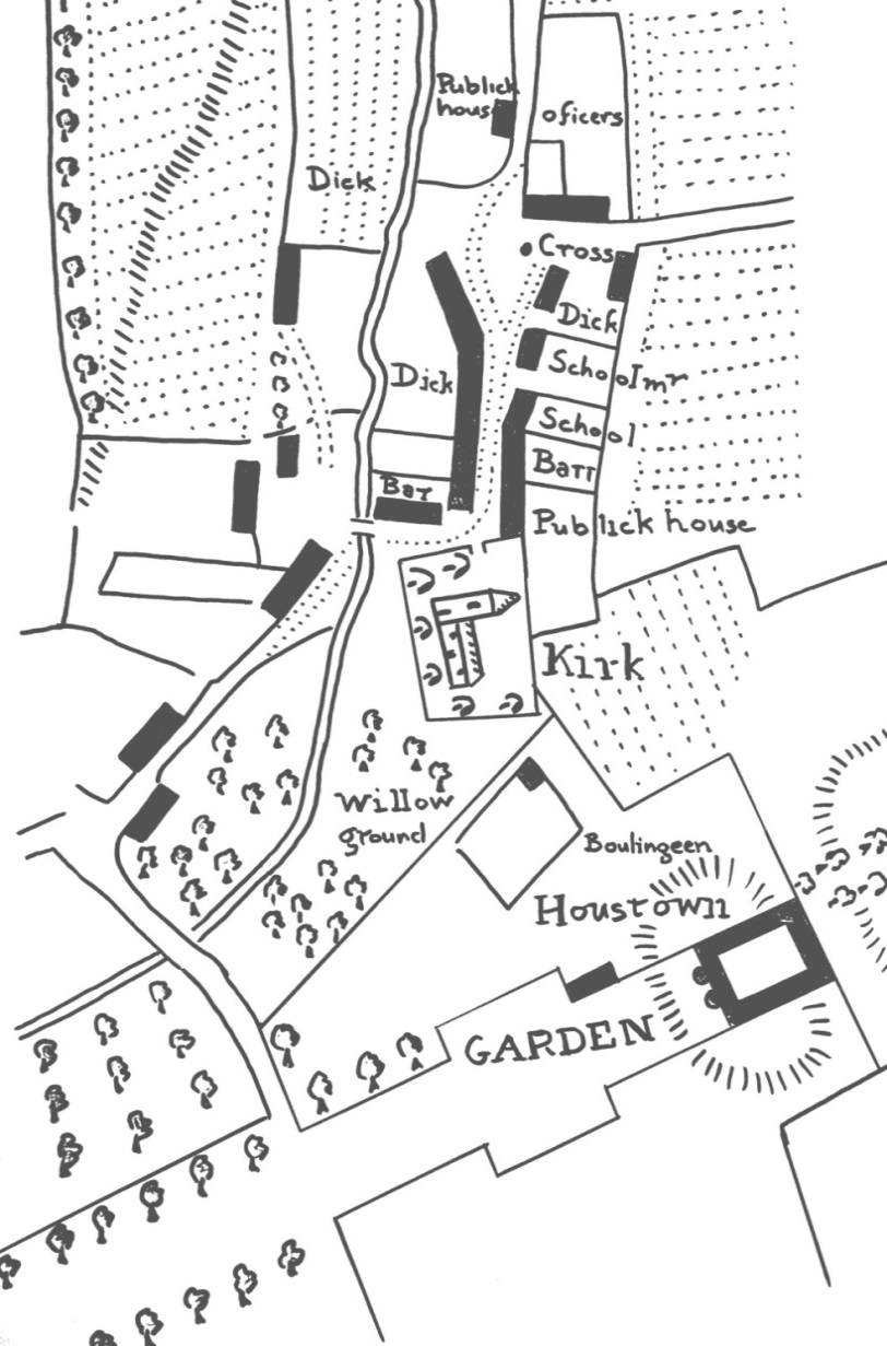
Due to the changes of owners and transformation of the estate around the time of the forming of the planned village, there was little evidence to confirm these descriptions. However the newly discovered estate plans, c.1780, show that the descriptions weren’t fantasy, but were in fact correct. They show a large square keep with a central courtyard, elevated on a mound. Even the turrets flanking the entrance can be seen on the plan.

The castle had a grand elevated setting, possibly on an earlier motte. It wassurrounded by parks and woodland. Around the house was a garden and bowling green. To one side was a ‘Pigeonhouse Park’ with a doocot. The great tree-lined avenue led south towards the River Gryfe.

By the 1780s towerhouses were in decline. Three sides of the castle were knocked down shortly after the survey was carried out, and the stone was allegedly used to clad the fronts of the new houses in Houston village. By this time the castle was described as being ‘once a large and very ancient mansion overlooking the whole country, from one of the finest spots’. By that time, only the east wing of the castle remained, but in a ruined condition, only big enough ‘to accommodate any ordinary family’.

© 2015, Stuart Nisbet, Renfrewshire Local History Forum

NOTES;     On the plan above  “Houstown” is the old castle

The large image above the title is of Houston House today, built on the site of the old castle.

The Old Village of Houston

Houston village was traditionally one of the seventeen parish villages or kirktouns in Renfrewshire. From the middle of the eighteenth century, Houston estate passed from the Houston family through various owners, the most wealthy of whom were colonial planters, including one from Jamaica, and another who was an island Governor. The biggest changes to the village occurred from the 1780s, again with sugar and tobacco money, when the whole estate was purchase by another colonial merchant, Archibald Speirs of Elderslie.

Speirs carried out a survey of his whole Houston estate, which comprised more than a thousand acres of Houston parish situated along the Gryfe Water, and north towards Barochan and Kilmacolm. The proposal was to improve the lands and also to create a new planned village. Building commenced in 1781 and two streets were laid out, parallel with the Houston Burn.

Unlike Bridge of Weir and Crosslee nearby, Houston has no river running through it. Despite this, and the rural situation, the very modest Houston Burn was managed to provide power and process water for at least five new industries to provide employment in the new village. Reservoirs were built further up the burn to store water. Four bleachfields were laid out along the burn. The largest, just west of the new village, was owned by the Carlisle family of Paisley, and whitened cotton yarn, sewing thread, muslins and lawns.

In the early 1790s, Paisley merchant Robert Park purchased land beside the avenue of Houston House, including Gardeners Acre, Goosebutts, Milnhouse and Saughfence Parks. Part of the area was flooded to create a reservoir, and
a lade was diverted off the burn to create a fall of thirty feet. This drove a water wheel, which powered a cotton spinning mill, four storeys high and a hundred feet long, employing 140 locals. Textile manufacture also provided the main employment in the village itself, with 42 looms in private houses, weaving cotton, muslin, lawn and silk gauze. There was also a small centralised ‘factory’ or weaving shop where handloom weavers wove expensive fabrics. In its first decade, the village population rose from sixteen families to fifty seven.

image

The plan shows the pre-1780 Houston village.

 “Houstown” is the old castle

The downside to the new planned village was that we have little record of the earlier pre-improvement village. Fortunately, in recent years, the estate plans surveyed c.1780 have been rediscovered. More than a dozen colour plans show each farm on the estate, plus the old village, just before the new village was laid out. They show the old village of Houston, including the school and two pubs, clustered around the market cross and the parish kirk, which had been rebuilt in 1775.

The Houston estate plans, can be viewed at the National Library of Scotland or by contacting RLHF.

© 2015 Stuart Nisbet, Renfrewshire Local History Forum

William Hair, Kilbarchan emigrant to Ulster and America

William Hair was one of the earliest Kilbarchan men known to have settled in America. He was born in Kilbarchan 1694, the youngest of the four sons of William Hair and Margaret Gardiner. His father was a tenant farmer in Birdland who paid a total of one pound and three shillings in Poll Tax in 1695. Previously the family had lived in Weitlands (Wheatlands). At this time both settlements were fermtouns, small farming settlements usually tenanted by more than one family. Wheatlands still exists today, but Birdland (variously spelled Boreland and Boarland) is long gone.

As a young man William Hair, like many Scots, moved to Ulster where he worked as a farm labourer. This move was not as successful as he had hoped and William became disillusioned. He and a companion John Paterson, who may have been a John Paterson born at Locherside in Kilbarchan Parish in 1693, set sail from Londonderry on a ship bound for Boston, America, captained by a Captain Dennis.

In 1719 William and John are recorded as single farmers from Ireland who had recently arrived in the town. However, Boston did not want to support jobless new arrivals. William Hair, now in his mid-twenties, and John Paterson were chased out of town because they were single and jobless. From there, they made their way to Providence and then inland to Brookfield, still in Massechusetts, where new arrivals were made more welcome. In 1720 they were granted a sixty acre lot of land in the north of Brookfield beside Five Mile River, where they set up a Fulling Mill. William built his house on the site. In his youth William may have had some knowledge or experience in this early-mechanised industry in one of the two fulling mills (known as waulkmills in Scotland) on the Black Cart near Kilbarchan.

William Hair was married three times and, between 1725 and 1755, fathered a large family of seven sons and seven daughters. When he married his first wife Elizabeth Owen in 1725, he was designated ‘a clothier, and first of the name in Brookfield’. Elizabeth was only fourteen years old when they married. Sadly, in the same year their first child Jane died in infancy. John Paterson and his wife Mary had a son John, born in 1724, and a daughter, Margaret born in 1726.

Both men still resided in Brookfield in 1748 when sixty-six tax-payers signed a petition to the Town Clerk of Brookfield asking for a second precinct with Parish privileges and a meeting house to be set up in the north of the town. Among the signatories were William Hair, John Paterson, sen., and John Paterson, jun. The proposal in the petition was rejected and after continued pressure the matter went to the House of Representatives, on March 25th, 1750. Eventually in 1754 an Act was passed, establishing the new Precinct. A congregational Meeting House was built and a Mr Forbush was appointed as minister.

William’s large family and their descendants, like most eighteenth century Americans, volunteered in the various American conflicts and wars which ravaged the country. Some family members were active in the frontier wars against the native Indians. William’s three eldest sons, Abraham, John and William fought for the British troops in the wars against the French in the 1750s. Twenty years later Abraham Hair fought against the British in the American War of Independence. John Paterson, jun. also fought for independence as a volunteer from Brookfield in Captain Nathan Hamilton’s company stationed at Ticonderoga Mills in 1776-7. In 1786, after Independence had been won, Hair family members supported local Brookfield man, Daniel Shay, in an insurrection by Massachusetts veterans and farmers to address economic grievances. This was known as Shay’s Rebellion.

Despite ancient wars and conflicts, descendants of William Hair from Kilbarchan still live in New England almost 300 years after William Hair arrived in Boston. Research into the family was inspired by an enquiry, to Renfrewshire Local History Forum from a descendant, Richard Hare of New York who, perhaps following the family tradition, was a USAF Captain in Vietnam.

© 2014 Helen Calcluth