Ralston Gudgeon in Callander

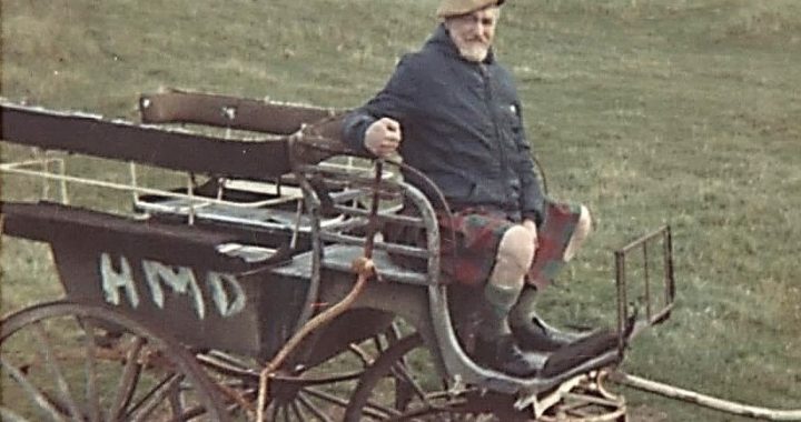
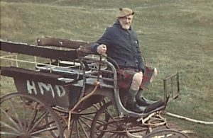
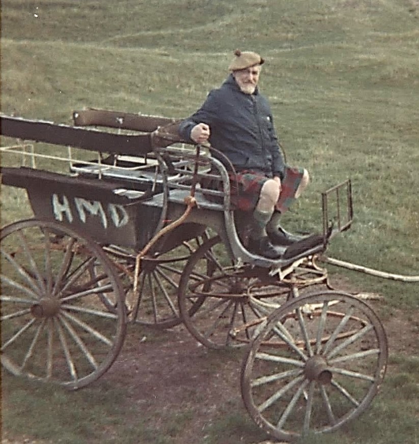
In Callander, Ralston is well remembered as one of the real characters in the town. He always wore a kilt, except for riding jodhpurs – and they were tartan as well. On some occasions he added a pheasant’s feather on his cap. He is known to have spent to have spent a holiday on Coll with friends from Callander in 1969 and, even on holiday, he dressed in his usual attire of kilt and cap

The Gudgeon home in the 1960s appears to have been a menagerie containing a diverse collection of animals and birds – numerous spaniels including Clooney, the big springer spaniel, and Tramp, the Labrador; umpteen cats; Ruadh, the fox; a hamster which ran around the house when “Gudge” and Mrs Gudgeon played the piano; and hawks, but the hawks were kept outside. One night Ralston brought his fox into the Shaftsbury Inn, and the landlord remarked that it was better behaved than many dogs.
The Gudgeon children’s friends in Callander were fascinated by Ralston. They would follow him along the street calling out the old rhyme, “Kilty Kilty Cald Bum”. To the delight of the children Ralston would turn round and roar at them. They all took it all in good part. On another occasion, Ralston was sitting with a group of children at the putting green telling them of his time in North Africa during the war and his friendship with an Arab sheik. The children were fascinated, but a bit sceptical about the story. Just then a large car stopped in front of them and Ralston’s Arab friend (whom he had been expecting to arrive) stepped out to greet him. The children were speechless! As well as being sociable, talented and a bit of a romantic, Ralston seems also to have had a mischievous sense of fun and humour.
This mischievous sense of fun was not confined to teasing children. He was not averse to playing tricks on his friends and neighbours. One lady recollects from her childhood that her father, Mr Macrae of Beinn Dorain in Main Street, was concerned that his stairway ceiling was so low that tall people banged their heads on the way up. He asked Ralston to paint a wee duck to place on the stairs to remind tall visitors to “duck”. Ralston obliged – but gave him a real duck’s head! In hindsight the lady thinks it might have been stuffed. (Ralston’s son, Lin’s hobby was taxidermy.)
Ralston was still full of fun in his late sixties. As a regular a customer in the Mairie Stuart Bar in Glasgow’s MacDonald Hotel, he persuaded the barmaid, Yvonne Falsay, to dress in the Royal Stuart tartan to match the name of the bar. An image of Ralston toasting Yvonne, dressed as Mary Queen of Scots, appeared in the Evening Times on 23rd August, 1978.
He is still fondly remembered by older residents in Callander as “a big handsome Scotsman” ; “a real one off and a true gentleman”; and “a fabulous neighbour”. Ralston died in Thornliebank in 1984. His wife, Jessie, lived to the age of ninety and died in a nursing home in Lundon Links on 13th November, 1999.
Do any Habbies have any memorabilia or old family stories of the artist’s life when he lived in Kilbarchan in the 1920s or 1930s?

Click to enlarge.

© 2023, Helen Calcluth, Renfrewshire Local History Forum

John Cuninghame, Laird of Craigends (1759-1822), 2

John Cuninghame, 13th Laird of Craigends, inherited Craigends estate in 1792. In 1800 he married his second wife, Margaret, the daughter of Sir William Cuninghame-Fairlie of Robertland. John and Margaret had five sons and six daughters.

His memorial stone in the entrance tower of Kilbarchan old Parish Church extols his kindness, wisdom, sincerity and his trust in God. It also makes mention of a protracted and painful illness which he bore with fortitude.

Despite suffering from frequent debilitating bouts of gout and arthritis John led an active life. His diary, written from 1814 to December 1815, provides a detailed account of his life.

John was responsible for the running of Craigends estate. This involved the organisation of haymaking, harvest-time, sheep shearing, tree cutting and pruning vines, engaging the mole-catcher, attending cattle fairs in Johnstone. In the winter of 1814, when the dam at Locher Mill burst its banks, he contracted William White to inspect the dam and make repairs. He held a regular Rent Court where he collected rent from his estate tenants. He also had a substantial income from Granville Estate in Jamaica and lodged his West-India income in a bank in Paisley.

John was a Justice of the Peace and a Commissioner of Supply for the County. In this latter capacity he was responsible for ensuring local roads and tolls were in good order. He had also a keen interest in a surveying and new building.  He visited the site for Napier’s new house on Milliken Estate and took his eldest son, Willie, to see George MacFarlane’s plans for his proposed new house at Clippens.

Religion was important to John, and the family regularly attended services in both Kilbarchan Church and Houston and Killellan Church. Margaret was especially friendly with Ann Monteith, the wife of the Houston minister.

John’s and Margaret’s social circle included the Napiers of Milliken, the Porterfields of Duchal, the Alexanders of Southbar, the Flemings of Barochan, the Napiers of Blackstoun and the Maxwells of Pollock. These family friends dined together, travelling from house to house by horse and chaise. On the 28th of November, 1815, soon after the marriage of William Milliken Napier to Elizabeth Stirling of Kippendavie, John was invited to meet the new bride. He found her “very agreeable tho’ not such a beauty as I had been led to believe she was”. The men enjoyed salmon fishing, shooting partridges and hunting with hounds. John hunted with his friends at Skiff in Johnstone, Kilmacolm, Barochan Mill, and Formakin Mill.

John had a close involvement in the home life of his children. He showed great concern when the children had chickenpox and promptly sent for doctor Pinkerton. He noted in his diary that Johnnie, aged ten, fell through the ceiling of the coal house, but thankfully was not badly hurt, and that Lillie fell off a chair and bruised her eye and cheek. On a visit to Paisley he took his daughter, Fanny, for a haircut.  He also recorded each of the children’s birthdays and arranged a holiday for them in Largs. His elder boys were tutored by Mr. Robert Smith, until the 2nd of March, 1815 when he was ordained as minister of Lochwinnoch Parish Church.

Entries in this unique personal diary ended on 26th December 1815. John died in 1822 and his eldest son, William, at the age of twenty-one, became the next laird.

© 2020, Helen Calcluth 

(See also previous article on John Cunninghame of Craigends (1759 – 1822) 

Castle Semple “The Temple”

Anybody travelling from Glasgow to Ayr by train, or driving on the A737 from Johnstone to the coast will be puzzled by an octagonal stone building on top of Kenmuir Hill, between Howwood and Lochwinnoch. The building is the most prominent feature on Castle Semple Estate, and commonly known as the ‘temple’. The prominence of the building has generated much speculation about its purpose.

Dating from shortly after the building of Castle Semple house in the early 1730s, the purpose of the ‘temple’ has been romanticised and lost. Ideas range from a place for viewing hunts to a local lovers’ meeting place.

The tradition that it was a hunting lodge dates from the 1780s, when the estate’s deer park was moved to Kenmuir Hill. However the deer weren’t for hunting, but were captive, to impress visitors. The whole of Kenmuir Hill was surrounded by walls and ha-has (boundary ditches with a stone face on one side, which could not be seen from a distance, giving the impression that the deer were free to roam).

The original purpose of the temple was simply a landscape feature or ‘folly’, designed to be seen from the mansion house and by visitors arriving at Castle Semple. It also served as a summer house with panoramic views. The design of the building probably comes from James Gibbs ‘Book of Architecture’, published in 1728, a sort of architect’s scrapbook of ideas. Gibbs described his designs as ‘summer houses in the form of temples of an octagonal form’.

According to a survey of 1780, the summit of Kenmuir Hill around the temple was originally planted with trees, forming twelve radiating avenues, a feature which was fashionable on estates at the time. The inspiration dates back to 1733, when surveyor John Watt, who originally laid out the estate for the McDowalls of Castle Semple, took sightings from the summit of the hill to distant features. These included Misty Law, the castles at Barr and Elliston, and church steeples as far away as Glasgow and Renfrew. But did the mapped trees ever exist on such a rocky, exposed hilltop? In fact they are indicated on Ordnance Surveys and a few survive in late Victorian photographs and sketches.

Inside the octagonal temple, the main floor (now gone) was elevated above a basement and accessed by an external stone stair, also now completely gone. Some of the basement windows were false and always blocked off, and the remainder were barred. The basement was entered from a low door under the stair. Inside the ruin are the remains of a fireplace and a very fine ashlar chimney in the roof. In the centre of the roof was a cupola matching the original on top of Castle Semple House. Externally, the panels between the ashlar details and window surrounds were originally harled and limewashed, and the building would have stood out on the skyline even more than it does today.

In the 1830s, Andrew Crawford of Lochwinnoch described the temple as being badly damaged by fire, following a lightning strike. However it was repaired, and the roof and glazed windows were still intact in late Victorian photos. However the condition of the temple deteriorated with the decline of Castle Semple House, and the breakup of the estate. It is only thanks to the quality of construction that it is still upstanding today, despite the loss of its roof. On a sunny day the walk to the summit is worthwhile and provides panoramic views of the area, and down Castle Semple Loch past the site of the McDowall’s mansion.

© Stuart Nisbet 2014

Water and Wind Power

Renewable energy, including wind and water power, is seen as a modern concept. Yet, in the days before heavy industrialisation, wind and water power were crucial for the development of Renfrewshire. Beyond mills for grinding grain and processing textiles, wind and water were used, particularly in mining.

Although the highlands of central Renfrewshire consist mostly of igneous rocks, coal and lime is available along the valleys of the Black Cart to Castle Semple, and of the Gryfe towards Bridge of Weir. The most ambitious landowners were keen to exploit these minerals on their estates. However, in the west of Scotland climate any hole made in the ground for a quarry or coal pit quickly filled with water. An early solution was to construct tunnels, known as ‘levels’ from the bottom of the quarry or pit to the nearest low point in the landscape. Once the level was completed, mining could carry on for many years, without fear of flooding. Early examples include the Corseford area with tunnels draining to the Black Cart. One of these still spouts water near the weir on the Black Cart at Elliston Bridge.

Once the quarry or pit became too deep to drain naturally, the water had to be pumped out. One method was to use horse gins, such as on the Speirs estate at Elderslie, where one or more beasts walking in a circle turned a wheel, lifting buckets of water on a rope. However, keeping and feeding horses was an expensive task. This encouraged the motivation to find an innovative source of power which could run day and night at little cost. The novel solution was to use water to drain water. By damming and diverting a burn along a lade, a fall could be created to drive a waterwheel. The wheel then powered a pump to drain the workings. The wheel could also be used to raise the coal or lime.

By the early eighteenth century water power was being used at Craigends, where ‘the water was taken out of the coal pits by a water engine, and great lime work was also carried on’. A lade from the Locher drove a water wheel, and a lime kiln and coal pit can still be seen.

Coal and lime working had been carried out in the Spateston area for a long time but any more organised working was plagued by flooding. The solution was an enterprise in 1776 between Houston of Johnstone and McDowall of Castle Semple to set up water powered drainage. Power was provided by the Swinetrees Burn, which flows from the foothills of Walls Hill. At Corseford, the water was dammed and carried to the water engine for a great distance on an elevated wooden channel.

The most lucrative coal reserves in the county were at Quarrelton, where the famous ‘100 foot’ coal was worked intermittently from the medieval period. By the 1690s drainage was provided by a pump situated over a shaft at the lowest point of the coalfield. The Craigbog Burn nearby was insufficient to power a water wheel, but was supplemented by an innovative scheme which diverted the Old Patrick Water three kilometres away. This fed a reservoir near Johnstone Castle. The water machine was situated near the former ‘Bird in Hand’ hotel, from where the lade still exits down the ‘Colliers Level’ in Linn Park. On a 1733 map of Quarrelton, covering five acres of Brownockhill farm, there were a dozen coal pits clustered around the water engine. In the early 1700s the engine was maintained by millwright, Neil Small from Kilwinning, who was paid for ‘maintaining, guiding, ordering and repairing the water wheel, pumps, gins and other machines for winning and out-taking the coal of Quarrelton and for draining the water therefrom’.

Other less obvious uses of water power were to grind Barytes at the mine at Muirshiels above Lochwinnoch. A previous article in the Advertizer showed how water was also used to pump water from the drained Barr Loch at Hole of Barr.

Where a suitable burn was not available, wind power was also used. At the lime works on the White Cart at Blackhall near Paisley in the 1780s ‘the water was taken from the lime quarry by a wind mill carried on by William King’. Another example was at the lime works at Boghall, on the west side of Windyhill, near Milliken, where a windmill is shown in Ainslie’s 1796 county survey. Such innovations allowed the early industrialisation of the area before the advent of steam power.

© 2013 Stuart Nisbet

The Forgotten Past of a Renfrewshire Farm

High Mathernock, seen here from its reservoir, replaced the earlier farm and settlement which were situated much closer to the Water of Gryfe

The village of Kilmacolm is surrounded by farms with names which go back at least as far as the sixteenth century and possibly to early mediaeval times. High Mathernock, on the north side of the Gryfe Water, is one of those farms whose forgotten history involving milling as well as farming is gradually coming to light.

The modern farm at High Mathernock has stood in its present location since the 1830s and was built in stages by the Shaw Stewart family for the tenant John Lang. Earlier activity at Mathernock, however, took place closer to the Water of Gryfe.

When Timothy Pont surveyed Renfrewshire in the sixteenth century he considered Macharnoch, the waulkmill, and Macharnay (possibly an older name for the nineteenth century Low Mathernock) significant enough to be mapped. All that remains of Pont’s Macharnoch which probably lay just north of Mathernock Bridge is possibly the few courses of stone wall low down on the river bank where, according to folk memory, there was a corn mill. There are two records of a corn mill on the site, one in a record of the Scottish Parliament in 1670, the other in a book about Renfrewshire written in 1782 which states that formerly there was a corn mill there. Further downstream on the other side of Mathernock Bridge lie the probable remains of the waulkmill in the form of a dam to deflect the water course, a partly silted up lade and the remains of walls. The still thriving patch of very old sloe bushes could have used in the dyeing process.

Eighteenth century records show a thriving community at Mathernock involved in a wide variety of occupations. The earliest Kilmacolm Parish Records up to 1745 don’t give occupations. However, in the second half of the eighteenth century we know that people made their living in a wide variety of ways e.g. living and working in Mathernock were a maltman, a smith, millers, farmers, a workman, a weaver, a dyster, a herd, a mariner, a ‘musiciner’ and many others whose occupations were not noted when they married or died. By the nineteenth century, all traces of milling and weaving had disappeared and the people of Mathernock were making their living as farmers and labourers, the principal farmers being the Langs.

Although many field boundaries have been erased by modern farming methods, there remain those which surround an irregular narrow enclosure running down a south facing slope towards the river. The farm of Low Mathernock lay here and before that the fermtoun of Mathernock. The footings and platforms of several buildings can be made out as can the line of the road between Kilmacolm and Port Glasgow, which can be seen on maps from the end of the seventeenth and beginning of the eighteenth centuries.

© 2012 Maggie Hancock and Jennie Hynd