This is the first of several articles on the mills on the Black Cart and its tributaries, from its source to the Clyde. The Black Cart flows all the way from Barr Loch, via Johnstone and Linwood, to join the Gryfe and the White Cart, before meeting the Clyde near Renfrew. The Black Cart itself powered at least a dozen mills. It is fed by various lesser burns which rise in the hills between Barr Loch and Kilbirnie Loch and define the Renfrewshire-Ayrshire border. These smaller burns powered another dozen mills
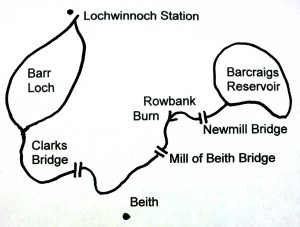
The Rowbank (or Moor) Burn forms the border between Renfrewshire and Ayrshire, between Lochwinnoch Parish and Beith. The burn is not very big, but it makes up for this by falling more than 100 metres, giving the potential to power numerous mills. Most were clustered around the three main bridging points of the burn.
At Clarksbridge, a toll point on the original turnpike road into Ayrshire (now the A737), there were several mills, including a lint mill (for dressing flax before it was spun) and a thread mill (for twisting yarn into sewing thread). Just above the bridge was Loanhead (or Rowbank) bleachfield and printfield, which became quite large. Further downstream in the 1850s, on a minor tributary, was a smaller bleachfield at Grangehill.
The next bridge up the burn from Clerksbridge was at Mill of Beith, an old grain mill on the Ayrshire bank. Just upstream, near Knowes, was a traditional waulk mill for fulling (or softening) cloth, to which was added the larger Knowes cotton mill in the early 1800s. Further up, also on the Ayrshire side of the burn, was another lint mill near Brownmuir.
At the third and final bridge, at the appropriately named Newmill, was another traditional grain mill, with a very long lade. The burn finally petered out on Shutterflat Muir and, via the Muirhead Burn, below Walls Hill.
Today the Rowbank Burn has been changed greatly by the whinstone quarries along its banks, and by Barcraigs reservoir at its headwaters. At its foot, the burn flows via the Dubbs Water, into Barr Loch. On the opposite side of the Dubbs, the Maich Water forms the boundary between Lochwinnoch and Kilbirnie Parishes. Near the foot of the burn was a water powered engine for draining a coal pit at Nervelstone.
The Dubbs Water is the high point of the rivers in the area, often flowing in both directions, draining the bogland between Kilbirnie Loch, the headwaters of the River Irvine (flowing east), and Barr Loch, which flows into the Black Cart, and begins our journey west towards the sea.
© 2016 Stuart Nisbet

