Visit to Glasgow Necropolis – arranged by Stephen Taylor, 22nd February, 2024
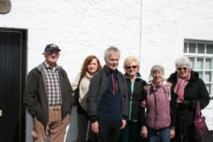
On Thursday the 22nd February, 2024, at 11.00.a.m., a group of our members from the Renfrewshire Local History Forum (RLHF), went on a booked tour of the Glasgow Necropolis. Our tour guide was Claire McArthur from The Friends of the Glasgow Necropolis, who organise daily tours at set times or booked tours.
The Glasgow Necropolis (City of the Dead), is located next to the Glasgow Cathedral and St. Mungo Museum of Religious Life and Art, both places that could be visited in the future. And of course, close to Glasgow Royal Infirmary. The Necropolis is home to approximately 50,000+ residents who are interred with the 37 acres of land, and is well worth a visit.
The Friends of the Glasgow Necropolis are a charity group who help to conserve the Necropolis and are reliant on donations to help with the upkeep of many of the memorials, such as repairing and repainting or replacing parts that are missing or stolen from the stone works. The work that the Friends do means that we can enjoy the Necropolis for generations. As mentioned before, some of the donations come from the tours. The booking tours are recommended at around £50 for a group of less than ten, and around £5 per person for groups exceeding ten. The Friends also sell post cards of the Necropolis and have two guide books on sale which can be used by those who wish to explore the Necropolis by themselves.
Why visit the Necropolis? The Necropolis is important as a window into the past lives of those who are buried there. Their stories shed light into their lives, from those whose wealth still funds projects today to those for whom money had to be raised to see them interred in the Necropolis. Each story is unique with some scandals, heartbreak, and murder. Some even tell the story of early medical science and others have been embellished with some fictional accounts. But each story is of a life lived, either long or cut short. The stories of those who reside in the Necropolis are all part of our heritage, of Glasgow and of Scotland – the wealth that was made by Scottish families and their enterprise, even of industries that we may wish to forget. The stories show a side to our country that is often forgotten. Each memorial also shows the thought behind the morality of the times, and each stone has its own symbolism that was popular in Victorian Britain.
When we went to this fabulous place, we learned a bit about the history of the Necropolis of the people who helped create it and whose money built it, and as mentioned before, their lives, told by our knowledgeable and enthusiastic guide. Before the day of our visit the weather had been poor resulting in some areas being slippery and dangerous underfoot, so we only saw part of the Necropolis in our hour and a half to two hour slot. We only scraped the surface. But, hopefully, in the dryer weather we will be able to access more of the Necropolis and hear more stories about the residents of old Glasgow.
______________________________________________________________________________
THE PEEL TOWER Fieldtrip – led by Helen Calcluth, Saturday, 28th October, 2023
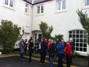
Our group of twelve met at the RSPB Centre in Lochwinnoch for our visit to the Peel Tower. The Peel Tower is a listed building of national importance. The weather, with some sunshine was amazingly pleasant for October. During the walk and exploration of the site everyone got to know one another and most of our group later went to Castle Semple Centre for a sociable coffee and chat. Everyone seemed impressed by the Peel Tower.
The Peel Tower was built in the early 1560s by Robert, 3rd Lord Semple, on a small rocky island in the middle of Lochwinnoch Loch. Subsequent owners of Castle Semple Estate partially drained the loch to create new farmland and the loch is now substantially reduced in size, resulting in the Peel Tower now being on an outcrop on the south bank of the loch.
The lower once vaulted chamber and parts of the exterior walling of what was once a fortified four storey tower have stood the test of time. The ruin was consolidated and made safe by the Partnership Project Garnock Connections in 2022 and a new walkway to the tower was erected to allow easy access to the site. Our first view of the tower from the end of the walkway was the south wall of the structure.
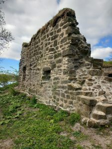
South wall, 2023, after restoration
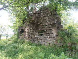
South wall, 2021, before restoration
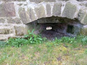
The structure had four gunloops, built into its extremely thick stone walls. Two were on the south wall and two on the north wall. Images below show one of the gun loops on the south wall after restoration.
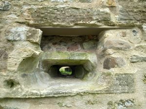
Gunloop on exterior of south wall
Gunloop on south wall from inside vaulted chamber
The interior of the once vaulted chamber in the ground floor has been consolidated and made safe. During recent restoration, presumably for safety reasons, soil was not removed from the interior of the chamber, so only the upper part is in evidence today. The present floor level is approximately 3 feet higher than the original floor. In the photograph the curved top of the renovated back wall further confirms the ground floor as a vaulted basement. The stair from the chambered vault to the storey above had fallen probably long before 2005.
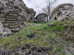
Interior of ground floor vaulted chamber, 2023
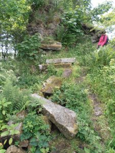
Fallen Stairs, 2005, before restoration
Thanks to the work of Partnership Project Garnock Connections, the site has been restored and made safe. The Peel Tower is now easily accessible from the RSPB Centre, and is well worth a visit.
______________________________________________________________________________
Visit to the Crannog Centre on Loch Tay, 4th April, 2023, arranged by Maggie Hancock
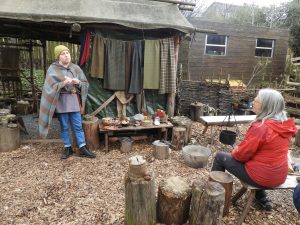
On Thursday 4th April 2023 fifteen Forum members visited the Crannog Centre on the south shore of Loch Tay. A few years before our visit the centre suffered a catastrophic fire in the replica crannog. Plans were already in progress to build a new centre on the opposite, north shore of the loch. However, the fire, which destroyed all but the main supporting posts of the crannog, changed plans more than a little, as visitors would no longer provide any income for some time to come. Fortunately, funding was obtained and plans for the new centre were able to go ahead. When we visited the centre on the south of the loch it was up and running with the original museum, shop and iron age craft displays carrying on as before.
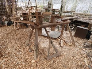
Demonstration of Spinning, G. Phillips
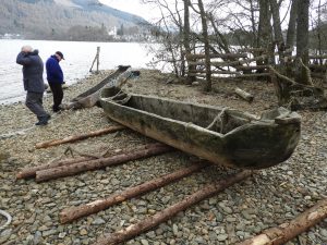
Dugout Canoe, G. Phillips
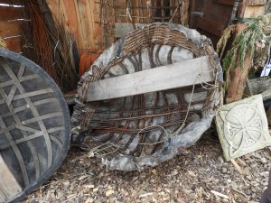
Coracle, G. Phillips
Worked Stones, G.Phillips
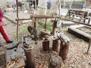
Foot powered Lathe
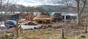
Iron Age Village under construction, with proposed new visitor centre to left
More than that, we were treated to an iron age lunch of vegetable stew, and a visit to the new site across the loch at Dalerb, where the new National Museum and visitor centre will be built in 2024. We were also shown the plans for the new visitor centre which will include three crannogs of different styles, and an iron age village.
______________________________________________________________________________
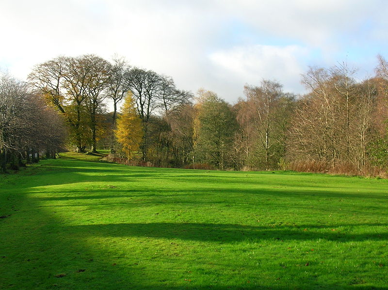
Rouken Glen Field Trip
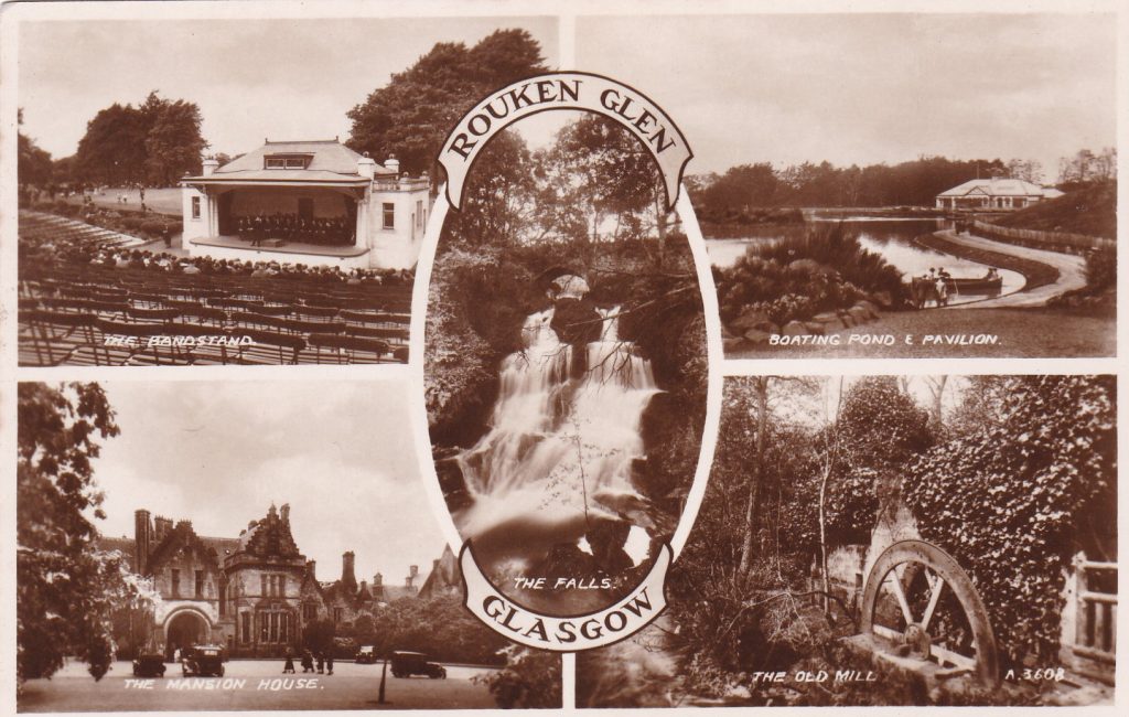
Saturday 16th November 2019
Forum member Andrew Eadie led eight of us on a guided walk around Rouken Glen Park. As one of the volunteers who contributed to a book published in 2016 – Discovering Rouken Glen Park: A History of the Park and its People, edited by Stuart Nisbet – Andrew was well qualified to show us round. We met in the Pavilion where tea and coffee were available while we looked at a range of photographs and maps which Andrew had laid out for the group. There is also a visitor area within the Pavilion with information boards and leaflets.
We were blessed with dry, still weather which added to an enjoyable walk.
The first mention of the area that now includes Rouken Glen Park was in a deed by Hugh, the 1st Earl of Eglinton. The name comes from Rokandmyll, a meal mill within the estate. After centuries of use for agriculture, industry and private recreational use it was gifted to the City of Glasgow in 1906. It immediately proved popular with local citizens who made good use of the pavilion, tearooms, two bandstands, children’s playpark and the curling pond as well as the grounds themselves.
A grant from the Heritage Lottery Fund financed the opening up of a previously difficult-to-access “wild” area of the park; paths were installed and they are now well used to enjoy the glen and woodland which, in contrast to the formal area of the park, is left largely untouched and natural.
We walked to the site of the 18th Century Rockandmyll, a grain mill. The HLF grant also enabled some archaeological work to be done around the park in 2014. Traces of the mill were found but the area is overgrown leaving little to see now. At the start of the walk we were able to see a small archway at the start of a lade, the exact route of which is unclear, that provided water to power a cotton mill and bleachfield, called Newfield, established in the 1780s . As part of the mill infrastructure a dam had been constructed and later modified into two bodies of water, one of which is now the duckpond. The other is a damp area with no depth of water.
We walked on over a bridge whose metal supports had originally been tramlines – a good example of recycling. We passed the ruins of a building which many had assumed to the original Rokandmyll but was in fact a folly to disguise the pumping mechanism to supply the mansion house with water. It is believed that it was an Armstrong hydraulic pump.
The archaeologists also opened a trench in the walled garden, revealing the site of one of long-gone glasshouses.
Rouken Glen is geologically important, with the Orchard Beds fossil site being of especial interest. Nearby, carved on a rock, are some more recent relics – names of apprentices who worked in the nearby meal mill.
We saw the site of the mansion house but nothing now remains to be seen. An archaeological dig revealed little of note – the site had evidently been efficiently cleared and is now manicured lawn with a small visitor shelter in the centre. The house was demolished in 1965 having suffered post-war neglect and then a fire in 1961.
The waterfall is a popular “natural” feature but is in fact only partly natural having been heightened by the 1820s to provide additional water storage for the mills downstream. The nearby steps were carved from the natural sandstone in situ.
Looking up from the path we saw an intriguing stone structure but far from being an archaeologically interesting relic it was a piece of modern art.
The boating pond was created in 1924 by extending the existing curling pond and is now used by model boat owners as well as the local swans and waterfowl. If you look across the pond you can just make out remains of rig and furrow cultivation.
We didn’t have time to visit them but just outside the park are also to be found a cup and ring marked stone, a fossilised tree trunk and the doocot. Sandstone and limestone were mined/quarried, and coal mining also took place.
While the Park contains some fine specimen trees planted by previous estate owners a more recent circular planting of trees is used by the local Druids for their ceremonies so use of the park continues to evolve. Nowadays it is very popular with walkers, dog owners and families at all times of the year.
After the walk we returned to the pavilion for another round of refreshments and a more informed look at the photographs and documents now that we had been round the park. Many thanks to Andrew for a most interesting morning.
______________________________________________________________________________
Visit to Glasgow Museum Resource Centre
On 4th June 2018 a group of fourteen of our members visited Glasgow Museum Resource Centre. Ioanna was our tour guide. She first took us to the Picture Gallery, then to galleries of Technology and World Cultures. Highlights of interest to our group were a display of early machinery, 2 turbine engines from Concord, the first x-ray machine, models of prominent buildings in Glasgow town centre, ceremonial wooden spears, Spanish ceramics, and dugout canoes.
______________________________________________________________________________
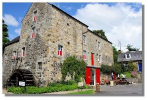
Visit to DALGARVEN MILL MUSEUM of Ayrshire Country Life and Costume
A group of Renfrewshire Local History Forum members visited Dalgarven Mill Museum on Saturday, 20th May, 2017. We gathered in the coffee room, where we met Mr Rob Ferguson, who took us on a conducted tour of the museum. The Ferguson family have owned the mill since 1922 when it was still a working grain mill. Mr Ferguson and the Charitable Trust he set up have transformed the old mill into what must undoubtedly be among the very best of country life museums in Scotland.
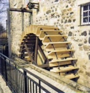
The historic mill building has been beautifully restored and the large waterwheel, on a lade fed by the nearby River Garnock, works the machinery in the mill. All the machinery required to run a grain mill, a large collection of farm implements, old kitchen and dairy utensils, trade tools and many more country life artefacts are housed on three floors of the museum.
On the ground floor we visited the current exhibition of Early Victorian Costume, 1810-1865, entitled “Corsets and Crinolines”. This excellent display is only a small part of the museum’s extensive collection of costumes. As we explored the upper floors of the museum our group was most impressed by the extensive collection of farm equipment and country life artefacts. Much of the collection has been donated to the museum by local farmers and other residents. A number of displays show typical period dwelling rooms. The sets are so skilfully designed that the characters seem alive and the viewer almost has a sense of being a welcome visitor within the characters’ home.
As well as a tour of the museum, our group was privileged to have access to the storeroom which houses the museum’s extensive collection of period costumes, and some other very exciting items which, as yet, are not on display
After our tour we retired to Miller’s Kitchen Coffee Room to sample its excellent menu. This was a fitting end to one of the Forum’s most interesting and enjoyable outings.
Images with kind permission of R. Ferguson, Dalgarven Mill Museum of Ayrshire Country Life and Costume. Further information and images can be found at http://www.dalgarvenmill
______________________________________________________________________________
HOUSTON VILLAGE, led by Bill Speirs
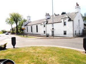
On Saturday, 22nd April, 2017, Bill led a most interesting historic walk round Houston village starting at Houston and Killellan Church on Kirk Road in what was the site of the old village of Houston, with its Mercat Cross and its now long-demolished church, castle and dwelling houses.
The present-day Church, built in 1870, replaced an older church building on the site. Bill had arranged for a church official to show us round the interior where effigies of an old 14th century Houston Laird (probable John or Patrick) and his wife are on display. Bill drew our attention to one of the oldest grave stones in the churchyard, and to the impressive monument erected by in 1828 in memory of George Cuninghame Monteath by his ‘afflicted widow’, Anne Colhoun Cuninghame, the daughter of the Laird of Craigends. George was a well-renowned physician and oculist in Glasgow, and the son of the Rev. John Monteath, the first minister of the amalgamated Houston and Killallan Church.
Medieval Gravestone
Graveyard Monument, George Cuninghame Monteath
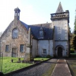
We next entered the nearby grounds of Houston House built on the site of the Houstouns of Houstoun’s old castle. Around 1800 the major part of the old castle was demolished by the new owner Alexander Speirs, and rebuilt as Houston House. In the late 18th century Alexander Speirs had built a new planned Houston village with North Street and South Street as its centre.
Houston House today
Our walk continued up Kirk Road to North Street in the ‘new’ village, with Bill giving us the history of many of the old dwelling houses and inns on the route, some dating as far back as the 1780s. We then stopped for a welcome coffee break in the Fox and Hounds, built in 1779.
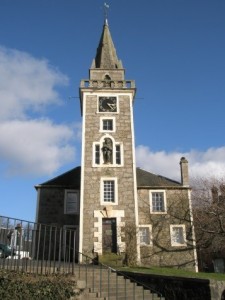
From there we visited St Fillan’s Roman Catholic Church. St. Fillan’s Church was established in 1841. Its bell tower was added some years later. The adjoining building on the right is the priest’s house. Before the church was established this building housed eight families, and what is now the church was a barn.
St. Fillan’s Church
We then made our way to the Mercat Cross in South Street. The Cross was moved from its original site in the old village and relocated in South Street in Alexander Speirs’s late eighteenth century village. The base of the cross is said to date from the fourteenth century and the sundial, which still accurately tells the time, is dated 1715.
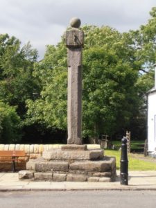
The Mercat Cross
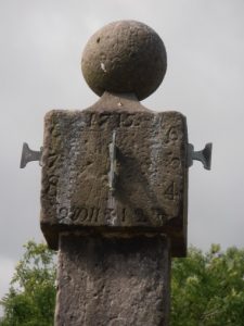
Sundial on the Mercat Cross
______________________________________________________________________________
LOCHCRAIG RESERVOIR AND SOUTH MOORHOUSE FARM – led by Susan Hunter
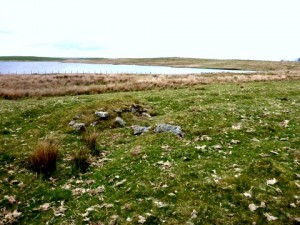
On Saturday, 2nd May, 2015, our group met at Mearns Kirk Church car park and went by car to South Moorhouse Farm where our walk started. The area has a wealth of archaeological remains, dating from the Bronze & Iron Ages. The weather was fine although the ground was waterlogged in parts. We set off from the farm over paths and moorland.
Susan showed us hut circles and a large enclosure from the Bronze / Iron Ages and more recent deserted farmsteads and long houses. There were also some enigmatic structures which promoted some lively discussion. One was evidence of a structure which appeared to have been built over a now dried-out burn or lade.
Another was a small rectangular building with a curved corner and a possible porch. This was on a lovely spot above the loch where we had our picnic lunch. Unfortunately we did not take many photographs. However, further detailed information on Susan’s research in the area can be found in her report, South and East Moorhouse Farms, Eaglesham Paper No.50, published by ACFA (2002).
Susan’s latest book “Eaglesham – The Farmlands and the Orry” has recently been published by ACFA (2016). This excellent book is a comprehensive survey of the archaeology of the whole area and will be available for sale at Forum meetings.
______________________________________________________________________________
FIELD SURVEY, Saturday, 11th April, 2015
Lurg Moor Romam Fortlet led by Derek Alexander
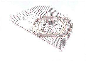
Computer data of Survey of Lurg Moor Roman Fortlet
Lurg Moor Roman Fortlet is situated on moorland above Port Glasgow and is part of the western flank of the Antonine frontier. It probably housed a cavalry patrol and is the only visible Roman remains in Renfrewshire.
After a long uphill climb and negotiating a few barbed wire fences we arrived at the sight of Lurg Moor Roman Fortlet. Evidence of the turf rampart and ditch round the fortlet and the entrance causeway were clearly visible on the ground, but there was no evidence on the ground of the wooden barracks and stables built within the fortlet.
The weather was disappointing, very cold, with a few blinks of sunshine, and with strong winds blowing across the site from the west – but we carried on regardless! Out of interest Derek gave us instruction on the use of a Plane Table. We then conducted a Total Station Survey of the site.
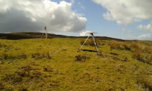
Equipment set up for Total Station Survey and Plane Table Survey
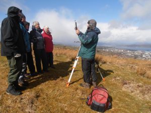
Instructions in use of Plane Table
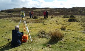
Team at work on Total Station Survey
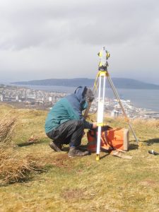
Derek at work on Total Station Survey
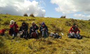
Lunch: Anne, Maimie, Helen, Jean and Bill in remains of north ditch with rampart to rear
______________________________________________________________________________
KILBARCHAN VILLAGE led by Helen Calcluth
On Saturday, 26th April, 2014, Helen Calcluth led a historic walk round Kilbarchan village starting at the ‘old terminus’ where the trams turned in the early part of the twentieth century. From there the walk continued along the Well Strand, and then up Ewing Street to Steeple Square. Leaving the Square for the Cross we passed the Old Manse (1730), the Weaver’s Cottage (1723), now a museum owned by NTS, to reach the old parish church (1724). The churchyard has a medieval tombstone irreverently built into the wall and the gravestone of Habbie Simpson, the renowned Kilbarchan piper. From the churchyard we continued down Church Street to the well commemorating Kilbarchan’s weaver-poet, Robert Allan and returned along Merchant’s Close and Yardshead to the centre of the village
The Steeple Buildings
______________________________________________________________________________
EAGLESHAM ORRY
Susan Hunter, led our first of a new series of field trips on Sunday 12th January 2014. This field trip focussed on the archaeology and history of the Orry in the middle of Eaglesham village.
Twenty members from the Forum, Eaglesham History Society and Mearns History Group attended. Luckily, in this time of seemingly constant rain, it was a dry day! The Orry, an A-shaped green area in the centre of the Eaglesham village covering 15 acres, is bordered on the north by Montgomery Street and on the south by Polnoon Street. It was gifted to the inhabitants of Eaglesham in the late 18th century by the 10th Earl of Eglinton as part of his planned village.
Susan started the walk at Glasgow Street at the bottom of the A-shaped Orry , pointing out areas of archaeological and historic interest as we made our way up the length of the Orry – the sites of old lades, tunnels and reservoirs on the Kikton Burn, old field boundaries , Moat Hill which was an early meeting place for judicial and other assemblies, Mid Road Bridge which was rebuilt by the feuers 1835, and sites recently identified by geo-phys surveys where old buildings formerly stood.
However, the highlight of the day was the site and archaeological remains of the New Orry Cotton Mill built in the middle of the Orry, probably in 1791. The mill was the principal employer in Eaglesham for more than seventy years with as many as 200 employees in 1845. The main building was an impressive five storeys high. The mill’s history ended when it was destroyed by fire in 1876.
The walk up the Orry ended at the site of the Earl of Eglinton’s dog kennels. We then visited the site of an of an older cotton mill built in the late eighteenth century at Townhead at the top of the old village. Finally we walked down Montgomery Street to visit the churchyard to see the Covenanter Memorial, commemorating the killing of martyrs Robert Lochkhart and Gabriel Thomson, who were put to death by the Highland Dragoons after attending a conventicle meeting in 1685.
Over a number of years, Susan has surveyed Eaglesham village and all the local farms and their land use. Her extensive archaeological field survey work is published in ACFA’s Occasional Papers. A detailed report on her survey of the Orry can be found in ACFA Occasional Paper No. 113 “Eaglesham Orry”, ed. Susan Hunter.
The Forum would like to thank Susan for ably leading the fieldtrip and sharing the results of her extensive surveying, research and knowledge on Eaglesham Orry. Everyone attending the fieldtrip found this a most interesting and enjoyable day. It’s going to be a hard act to follow!!